Radar Mapping the Moon
Unlike a photograph, radar provides its own illumination – the pulses sent to the surface are reflected, received back and converted into an image.

The first images obtained by the Mini-SAR radar instrument aboard the Indian Chandrayaan-1 spacecraft, currently orbiting the Moon, were released yesterday. Although the spacecraft arrived last November, we are only now getting ready to map the poles of the Moon. The data released are test images, designed to make certain the instrument is working properly, that we can command it properly and that the end-to-end data stream from the Moon is configured correctly.
Imaging radar works by sending a series of pulses which hit the Moon and are reflected back to the spacecraft. The range to the surface (measured by the time lag between send and receive pulses) and velocity of our instrument relative to the target (indicated by the slight Doppler shift in frequency) are determined and stored as data. These data are sent down to Earth, where we reconstruct the information into an image that shows the radar reflectivity of the Moon’s surface as a function of position. The result appears similar to an optical image but is very different.
Unlike a photograph, radar provides its own illumination – the pulses sent to the surface are reflected, received back and converted into an image. It is this effect that allows us to “see” into the permanently dark areas near the lunar poles. Another difference is that radar images slightly penetrate the lunar surface to illuminate and image the subsurface structure. The depth of penetration depends upon the wavelength of the radar system, typically a few tens of wavelengths. In the case of Mini-SAR, our wavelength is 13 cm and we are looking into the Moon to depths of about 1 to 2 meters, the uppermost portion of the lunar regolith.
Our objectives are to map the poles of the Moon, examining the permanently dark areas and characterizing their surface properties. These dark areas never see sunlight and are extremely cold, only a few tens of degrees above absolute zero. Because the Moon is bombarded with water-bearing objects such as comets, we think it is possible that water might be trapped in these dark zones near the poles. Radar is reflected from various surfaces in different ways. The reflections from rock and soil are very different than those from ice. By mapping all the dark regions and determining their surface backscattering properties, we hope to identify any possible ice deposits, even though they cannot be seen with visible light.
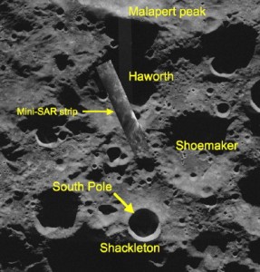
The image released shows the interior of the lunar crater Haworth, a 35 km diameter feature just north of the crater Shackleton, at the south pole of the Moon. Because Haworth is both deep and partly shielded by the bulk of Malapert Mountain just north of it, its floor is in both Sun shadow (never being illuminated by the Sun) and in Earth shadow (meaning that radar from Earth-based radio telescopes cannot see into it). Mini-SAR has given us our first look into the dark interior of this crater. We see that it has a relatively flat floor, with numerous other craters formed on it. We have not yet analyzed its backscatter properties, but the data are of sufficient quality that this analysis is possible. The first Mini-SAR images mostly show that the instrument is working properly. Future collects will image large, contiguous areas and gather high fidelity information that will allow us to identify and map the extent of anomalous reflective properties.
Despite some sensationalistic and inaccurate news reporting, we have not yet found any deposits of ice, or even any “extremely hard surfaces.” (By the way, hard surfaces are not absent from the Moon – they can be found wherever bare rock is exposed, for example, in outcrops along crater and rille walls or the surfaces of very young features, like the solidified pools of shock impact melt in King crater). I’ve been down this road before: a quick look at some data, someone shoots off their mouth, and the press takes it from there. Not this time. If we find something interesting, we will repeat our observations, probably several times, to make sure that the data is good before any interpretations are announced. So beware of what's reported in the news.
I am very pleased and excited to get new data from an instrument never before flown to the Moon. I’m looking forward to the next few months, when we’ll get our full allocations of mapping time to build up our polar mosaics. The search for lunar ice has only just begun.
A Postscript
Emily Lakdawalla has noted the public release of Mini-SAR images on her blog at The Planetary Society. She seems somewhat disappointed in the appearance of the images, noting that they seem "less crisp" than other SAR images she has seen. She attributes this lack of "crispness" to the smoothness of the Moon itself (features being eroded by the constant rain of micrometeorites) and to the compact miniaturization of our SAR instrument (Mini-SAR is less than 10 kg in mass, smaller than any previous space radar).
Neither explanation is correct. The principal reason for "crispness" of SAR images is the presence of cast shadows. Mini-SAR uses an incidence angle of about 35 degrees; as one of our main objectives is to search for ice on the Moon, we chose this imaging angle deliberately to enhance the backscatter signal from the surface, making the identification of ice easier. In fact, for our purposes, cast shadows are not desirable because we want to map all of the dark areas near the pole -- a cast shadow represents an unmapped area.
It is difficult to judge context from a narrow strip image. As we build up our contiguous mosaics of the poles, the radar images should be easier to examine and interpret.
/https://tf-cmsv2-smithsonianmag-media.s3.amazonaws.com/accounts/headshot/blog_headshot_spudis-300x300.jpg)
/https://tf-cmsv2-smithsonianmag-media.s3.amazonaws.com/accounts/headshot/blog_headshot_spudis-300x300.jpg)