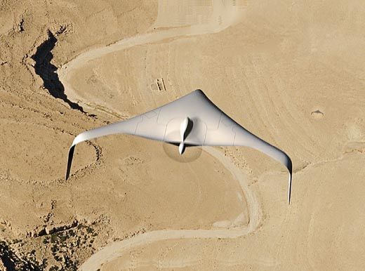
Unmanned Traffic Jam
To the Federal Aviation Administration, civilian UAVs are the new barbarians at the gate.
/https://tf-cmsv2-smithsonianmag-media.s3.amazonaws.com/filer/Today_UAV_Flash_JJ09.jpg)
Above a potato patch in the rolling green hills of southwest Virginia, two small airplanes buzz insistently on an August morning, cutting tight spirals through the misty air. Attached to each wing of the small unmanned aerial vehicles (UAVs) are canister-like traps. What they’re trapping are tiny sporangia. Potato-blight sporangia.
Elson Shields, a professor of entomology at Cornell University in New York, is an expert in using remote-controlled UAVs as a scientific tool, and the researchers on his team are flying the aircraft. He brought the UAVs to this Virginia potato patch, owned by Virginia Tech University, to help university professor David Schmale. Several weeks earlier, Schmale had deliberately infected a crop of red potatoes with sporangia of Phytophthora infestans, the same pest that devastated Ireland’s potatoes in the 19th century, sending a million starving immigrants to the United States, Canada, and Australia.
The field is covered with the blackened, curling leaves of dying potato plants. As the sun warms the air, the tiny sporangia take flight on rising air currents, hopping from one pasture to the next. In a matter of days, they may travel hundreds of miles, but little is known about how they travel, how high into the atmosphere they reach, and how long they remain viable once they’ve taken flight. These are the things Schmale wants to learn. Potato blight is still a threat, with no commercial tuber fully resistant.
Agricultural research is only one of many commercial uses for UAVs. Entrepreneurs across the United States are eyeing them for chores ranging from surveying fields to spotting forest fires to photographing highway accident scenes. But first, UAVs have some hurdles to jump. The idea of the nation’s airspace filled with hundreds of pint-size aircraft—some remotely controlled, some operating entirely on their own as autonomous craft—has the Federal Aviation Administration in a cold sweat. While the FAA has been issuing Certificates of Authorization (licenses to fly, referred to as “COAs”) for UAVs, the permits are just trickling out, not nearly fast enough to meet the clamor for them. “We’re at a standstill because we can’t get COAs,” says Ross Hoag, co-founder of Cloud Cap Technology, an Oregon company that makes control systems for military UAVs and would like to do the same in the commercial sector.
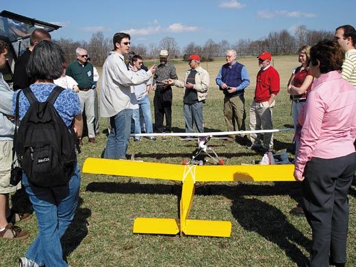
Above the Blacksburg potato fields, Schmale and Shields conduct two sessions tracking the epidemic’s progress. This morning, persistent fog over the nearby New River grounds Shields’ little aircraft fleet. The bright red, yellow, and blue aircraft—built by Shields and his crew—have 10-foot wingspans, weigh 45 pounds, and are powered by 50-cc engines. “It’s like flying a semi-truck,” says Shields, a tall man with a shock of white hair poking out from under a baseball cap. “They’re quite heavy when fully loaded, and they have to be rugged and durable because we often fly from rough airstrips.”
By 10:30 the fog lifts, and things happen fast. Shields spins the UAV’s propeller and the little engine catches. Grabbing a remote control unit, he toggles the controls to steer the craft down its takeoff path in a roughly mowed field. It bounces a few times, then zooms into the air. A second aircraft soon follows. Shields hands the controls to two support staff (“I take them off and land them,” he says), then walks across the field to the planned flight path. In a nearby trailer, a radio downlink feeds computer screens the aircraft’s speeds and elevations. The data will be used to ensure the aircraft fly as consistent a path as possible.
Once the craft are airborne, the doors covering the sporangia traps snap open for exactly 30 minutes. By examining the record of each aircraft’s speed, the researchers can calculate how many cubic yards of airspace it flew through, determine the number of sporangia in the trap, and compute the density of sporangia in the air.
Flying the mission with piloted aircraft would cost much more, but Shields’ fleet of airplanes has its limitations. They require a considerable entourage of operators on the ground: an observer, required by the FAA, to scan the skies for other airplanes, and personnel to change the traps between flights, refuel, and download flight data onto a laptop. And the precision of the UAV’s flight paths—critical to accurate measurement of anything from blight spores to insects (which Shields collects by UAV for his own research)—depends upon the skill of the person managing the toggles.
It’s easy to see why Schmale and hundreds of scientists, farmers, police, researchers, firefighters, and others believe that capable, easy-to-fly unmanned aerial vehicles can do their bidding. As is the case with dozens of other innovations, these birds were first launched by the military. The skies over Iraq and Afghanistan are fly-specked with UAVs, spotting targets, firing missiles, and scouting for roadside bombs. The key hardware—sensors that give UAVs useful vision and controls that put them where people want them—was developed for military operations. Perhaps as a result, the UAV industry in the United States today is robust, with makers of aircraft, control units, sensors, and more scattered across the country.
Sometimes companies pop up in unlikely places. One nexus of UAV development is Hood River, Oregon. This small town, on the Columbia River, 60 miles east of Portland, is best known for the apples that grow on hillside orchards above it, and for the brisk winds that roar along the Columbia below it, making the sport of windsurfing enormously popular here.
In 1994, the UAV firm InSitu Inc. set up shop across the Columbia in the little town of Bingen, Washington. Several years later, in 1999, InSitu alumni Bill Vaglienti and Ross Hoag decided Hood River looked like a good bet and moved there to launch their own company—Cloud Cap Technology. The firm has emerged as one of the leading suppliers of the brains of today’s UAVs—the autopilots and payloads that fly the craft and see what needs to be seen.
Inside the two-story Cloud Cap building, computer geeks mingle with mechanics. Around the building are scattered half-assembled miniature aircraft and helicopters; workbenches are stacked with electronics gear, computers, and partially constructed control units.
“We make the enabling technology,” says Mark Zanmiller, the hardware engineer who leads Cloud Cap’s technical sales and marketing group. As sensor technology evolves, inertial and air pressure sensors get both better and smaller; Cloud Cap’s designers are now turning out UAV controllers dainty enough to fit in a coat pocket but packed with amazing capabilities.
One of Cloud Cap’s competitors is CropCam, a division of a company called MicroPilot, a manufacturer of military UAV control systems. CropCam is essentially a lightweight (six pounds) powered glider, equipped with electronic control systems and a Pentax Optio digital camera. It has a ground-based remote control station, but instead of requiring a pilot-operator, the station is used to input GPS-based waypoints, desired elevation, and other flight parameters. (Manual remote controls can be used as a backup.)
After CropCam takes off, it uses the information sent from the remote control station to fly its route and snap photos. Software stitches the photos together for a seamless look at agricultural lands, so farmers can check seed coverage, gauge irrigation effectiveness, and spot early signs of insect infestation. Its high resolution—images taken at 2,100 feet have a resolution of 15 centimeters—“blows satellites away,” says project director Lisa Shaw.
Idaho farmer and UAV convert Robert Blair previously used to monitor his fields with a small, piloted airplane. But getting photographs of his crops that way was expensive—$6,000 for a survey of 1,500 acres—and the airplane had to be booked weeks in advance. So in 2006 he bought a CropCam for about $18,000 and began taking his own aerial photos.
Flying the little UAV isn’t hard, Blair says. When needed, he loads the craft into his pickup—its wingspan is only eight feet—and heads to his fields. Using grid coordinates, he programs the flight path and sets the desired altitude (usually 900 feet). After a quick flight check—rudder and aileron function, battery connection, a look around to ensure the airspace is clear—he starts the engine and simply tosses the craft into the air. “I have it flying in about 15 minutes,” Blair says.
And the results, he says, are amazing. Using digital photos and a computer program to analyze them, Blair can examine his crops for insect damage, lack of water, and more. “We can verify what’s going on out there in the field,” he says.
Blair was so impressed with CropCam, in fact, that he first became a vendor for the company, then created his own company to market UAVs—still in the prototype stage—of his own design, through PineCreek Precision. Technology such as CropCam or his own PineCreek designs, he says, “is what’s going to save the small farmer in the United States.”
UAVs such as CropCam are light, easy to use, and not very expensive. But bigger, more capable UAVs—also based on military designs—are gaining use, at least where a potential mishap doesn’t put people or property at risk.
Last summer, for instance, researchers from the National Oceanic and Atmospheric Administration (NOAA) flew a pair of UAVs over the Greenland ice sheet. Tucson, Arizona-based Advanced Ceramics Research developed the craft, called Manta, for military use. But the pusher-type, propeller-driven craft have a payload capacity (up to 15 pounds) and range (eight to 10 hours of flight time at around 92 mph) attractive to a wide variety of users.
Flying over meltwater-fed lakes atop the ice sheet, the Mantas measured the sunlight penetrating the lakes, allowing researchers to determine their depth and their potential for draining through the ice sheet and out to sea. (Understanding the behavior of the Greenland ice sheet has become critical in recent years, with some scientists predicting that global warming could dump vast amounts of water, now in the form of ice caps, into the oceans.) Because flying over remote areas like the Greenland ice sheet is risky, the task is better suited to unmanned craft.
Perhaps even more ambitious is a NOAA project employing UAVs as hurricane hunters. In 2007, a craft developed by Aerosonde flew into the eye of Hurricane Noel as the fast-growing storm approached the East Coast. The NOAA craft loitered inside the hurricane for nearly eight hours, flying below a height of 325 feet as it measured winds and air temperature. That’s far lower than manned hurricane-watching aircraft such as NOAA’s four-engine P-3 Orion would dare go.
“It’s really useful to take an unmanned aircraft to those lower elevations, as the risk of catastrophe [with a manned aircraft] is just too high,” says Marty Ralph, a research scientist with NOAA’s Earth System Research Laboratory. Costs also are much lower with UAVs, he says, so more projects can be pursued.
Because of the sheer versatility of UAVs, their missions are for the most part limited only by imagination. A case in point: In April 2008, NOAA experimented with a UAV built by Airborne Technologies, based in a town that by November 2008 everybody had heard of: Wasilla, Alaska. The aircraft, called the Resolution, was used in the north Pacific to hunt for ghost nets—drift nets that have escaped from fishing vessels and then float with the current, devastating marine life. (By some estimates, ghost nets in the north Pacific alone cause thousands of birds and marine mammals, such as porpoises and seals, to drown each year.)
The Resolution is equipped with video sensors that can detect anomalies in the water; GPS sensors automatically mark the location of nets it finds, for recovery by boats. While the Resolution takes off and lands with the help of a shipboard pilot, it flies its route autonomously.
Autonomous flight is what really gets UAV supporters enthusiastic. Such aircraft could hunt for forest fires, for instance—or, more usefully (since finding a forest fire is rarely difficult), fly the night missions fire managers rely on to map the size and intensity of a blaze through infrared sensors. For his research on plant pathology, David Schmale could use multiple autonomous UAVs to find and track plumes of airborne pathogens, measuring the plumes’ size, direction of drift, speed, and more. In the event of a terrorist attack, such UAVs could track airborne chemicals or biological agents.
And in Utah, where state laws require highway patrol officers to photograph injury accidents, troopers are interested in carrying UAV helicopters in the trunks of their patrol cars. At an accident scene, a trooper could punch in some GPS coordinates and the little helo would take off, buzz over the specified grid, take pictures, and land.
For the most part, the machines are here today. The big challenge, says Jonathan How, a professor at the Massachusetts Institute of Technology, is designing an airspace they can fly in. “All GPS tells an aircraft is where it is,” says How, who designs autonomy software for UAVs. “Flying safely also requires [knowing] what else is out there.” Achieving that will require communication between aircraft, or visual sensors on the aircraft, or data sent from ground stations.
“I understand what they want to do—I heard a DOJ [Department of Justice] guy talking about the Utah proposal,” says Kenneth “Doug” Davis, a longtime FAA official who now is running the agency’s program on managing UAVs in the national airspace. “But there are 19,000 law enforcement agencies in the United States. Of those, fewer than 300 have aviation units. So less than two percent of these guys have a clue about what constitutes ‘airworthiness.’ ” In terms of teaching potential UAV operators the rules of aviation, he says, “we have a big education gap to fill.”
Davis points out that today’s UAVs—which can resemble everything from an insect to a small piloted aircraft in size—simply don’t fly the way other types of aircraft do. “An airliner operating at 30,000 feet can move 500 knots across the ground,” he says. A UAV “might have the thrust to reach 30,000, but then it’s moving at only 100 knots. That creates a big challenge for integrating slower aircraft into the airspace.”
The FAA issued 165 Certificates of Airworthiness for UAVs in 2008, up from 85 in 2007. The agency, which hopes to pick up the pace, is working on new regulations and plans to start gathering public comment late this year and into 2010.
Still, creating guidelines for operating UAVs is going slowly, and that frustrates plenty of people. “The FAA wants us to show these things are safe, but they make it difficult to fly them to collect the information needed to prove they are safe,” says Massood Towhidnejad, a professor of computer and software engineering at Florida’s Embry-Riddle Aeronautical University who studies potential UAV applications. “Look, I agree with some of the [FAA] restrictions. But I don’t agree with others. We all agree with the FAA’s position that safety of the public should be the highest priority in any decision they make, and it’s unrealistic to assume [the FAA] should allow UAV systems to fly over any area that could result in human loss or injuries, or property damage. However, if the request is for a flight test over an area where’s there’s almost no chance of danger to humans or property—in the middle of the ocean, say, or over a desert—there’s still a good chance the FAA won’t approve the request. It’s obvious that the expected damage generated from the crash of a Predator is much higher than a small six-foot-wingspan UAV. And yet the FAA allows hobbyists to fly remote-controlled model aircraft very close to—or even in—cities, but they don’t allow a UAV of the same size to fly the same areas. If we could get more UAVs flying, they could play a major role in society.”
Another Embry-Riddle professor, Richard Stansbury, who specializes in robotics, sees fleets of larger UAVs eventually providing delivery services for UPS, FedEx, and other air freight companies. “It just makes sense to have [UAVs] do that,” he says.
The day after he and Elson Shields flew their UAVs through a cloud of potato blight, David Schmale returned to the field to test his autonomous UAVs. Three of them took off and began to pirouette through the sky, flying precisely and gracefully, learning to work together to track a pest that could do tremendous damage. It’s anyone’s guess how much else they could track.
Douglas Gantenbein can think of about a million uses for civilian UAVs.