In the 1920s, Only One Man Held the Key to Aerial Navigation
Even Lindbergh got lost.
/https://tf-cmsv2-smithsonianmag-media.s3.amazonaws.com/filer/Lindbergh-Lost-631.jpg)
In the year following his historic transatlantic flight to Paris, Charles Lindbergh, flying again in the Spirit of St. Louis, lost his way somewhere between Havana, Cuba, and the southwest coast of Florida. It happened in the middle of the night, and it alarmed Lindbergh enough that years later he recalled the incident in his memoir The Autobiography of Values:
Over the Straits of Florida my magnetic compass rotated without stopping…. I had no notion whether I was flying north, south, east, or west. A few stars directly overhead were dimly visible through haze, but they formed no constellation I could recognize. I started climbing toward the clear sky that had to exist somewhere above me. If I could see Polaris, that northern point of light, I could navigate by it with reasonable accuracy. But haze thickened as my altitude increased….
Nothing on my map of Florida corresponded with the earth’s features I had seen…where could I be? I unfolded my hydrographic chart [a topographic map of water with coastlines, reefs, wrecks and other structures]…. I had flown at almost a right angle to my proper heading and it…put me close to three hundred miles off route!
Had this occurred nine months earlier, over the Atlantic, the name “Lindbergh” might today be no more than a forgotten bit of aviation trivia. His nearly tragic Caribbean trip, however, turned out to be a critical moment in time, not only for Lindbergh’s understanding of navigation, but also for the advancement of the practice for all aviators. A few months later, the newly famous pilot would meet a young Naval officer, and their collaboration would change the world of flying.
It may be hard to believe Lindbergh didn’t learn to navigate until the year after his nonstop New York-to-Paris flight, but in 1927 the practice was still more art than science. Aviators had attempted to cross the Atlantic with various degrees of success since 1919, but they were still using tools and methods designed for seafaring, and those were proving unsuitable for the skies.
When Navy Commander John Rodgers attempted the first flight from California to Hawaii in 1925, the expedition ended disastrously, illustrating just how unreliable the equipment could be. Though they carried sextants, Rodgers’ crew lacked confidence in the sightings they made from their PN-9 flying boat. Instead, they relied on radio navigation, finding their bearing by determining the direction of signals transmitted by support ships along the route. But the technology behind these ship-based direction finders was still subpar, and combined with operator error, led the PN-9 to miss a refueling ship. Out of fuel, the airplane was forced to land in the ocean hundreds of miles short of Hawaii. The crew spent a valiant 10 days sailing their flying boat to the Hawaiian island of Kauai, in what was perhaps the greatest feat of seamanship ever accomplished by airmen.
By the end of World War I, some pilots were using bubble sextants, which in flight substituted an artificial horizon for the actual horizon on which mariners depended, as well as radio navigation, but Lindbergh decided that for his Paris flight, the devices were both cumbersome and ineffective. The Spirit’s high wing obstructed his view of the sky, making star sightings nearly impossible. Even if he’d had a clear view, it would have been too big of a challenge trying to take sextant measurements with one hand while controlling the unstable Spirit with the other, then scribbling calculations that took a trained mariner 15 minutes, all done by a single pilot forgoing sleep on a 33-hour flight. Radio navigation, the method that sent John Rodgers sailing to Hawaii, was clearly unreliable and the equipment was heavy.
Instead, Lindbergh reasoned that his airplane’s payload was better used for extra fuel that could be consumed to correct any significant deviations from the flight plan once he reached land; Western Europe was, after all, a big target. He relied entirely on dead reckoning, calculating his position from point to point by tracking his airspeed. He used a clock and compass just as he had between checkpoints while flying airmail.
In spite of all of the obstacles, Lindbergh still made landfall in Ireland within three miles of his intended site, an extraordinary feat. Did he possess some kind of superhuman sense of direction? His skill in maintaining a heading while exhausted is an indisputable achievement, but the National Aeronautic Association observer for the flight, John Heinmuller, also noted that the pressure distribution over the Atlantic on the two days of the flight was such that the net wind drift was zero—“the first time such unusual weather conditions have been recorded by weather experts.”
The magnitude of Lindbergh’s accomplishment led many to believe that transoceanic air navigation was simply a matter of determination. At least 15 people died in ocean-crossing attempts through the rest of 1927, leading to calls for federal regulation. While inexperience played a role in many of these accidents, inadequate navigation technology had let nearly everyone down, causing everything from inconvenience to fatalities.
Lindbergh watched in anguish as others attempting his feat disappeared at sea. After finishing his Latin American and Caribbean tour with the Spirit of St. Louis in early 1928, he was eager to find better equipment and procedures for future flights. Though he had dismissed celestial navigation for his trip to Paris, during his return aboard the USS Memphis he was enthralled with the ability of the ship’s navigator to fix position with sun and star sextant sightings, and he resolved to pick up the skill, writing, “It was a lot of fun ‘shooting the sun’…with the Memphis sextant. I was fortunate enough to hit it with a fair degree of accuracy.”
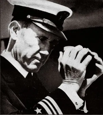
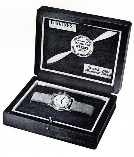
Upon his return, Lindbergh began planning an around-the-world flight, scheduled to kick off a few months later in a Ford Tri-motor provided by Henry Ford and copiloted by his close friend, Thomas Lanphier. That April, he went to observe air operations aboard the USS Langley, where he encountered an enthusiastic Navy Lieutenant Commander, Philip Van Horn Weems, who was conducting navigation experiments for carrier-based aircraft. Weems demonstrated several of his innovations to Lindbergh, including a bubble sextant that he was helping the National Bureau of Standards to improve, and his prototype Second-Setting Watch: the first true aviator “hack” watch that could be set precisely to the second. (Later, the military realized a major benefit of this precision, and began to synchronize multiple watches for field operations, thus making famous the line “Gentleman, synchronize your watches.”)
Several weeks later, after donating the Spirit to the Smithsonian Institution, Lindbergh decided he would set out from Washington for Detroit to finalize his plans with Ford and Lanphier. He felt the trip would be an ideal time to learn “avigation”—a popular term used in the 1920s and ’30s to differentiate air navigation from maritime practice—and asked polar explorer Lincoln Ellsworth for suitable tutors. Ellsworth recommended Weems.
Shortly after Roald Amundsen’s 1925 Arctic flight, in which the crew was nearly lost after a crash-landing, Ellsworth had begun looking in earnest for better aerial navigation techniques. At the time, Weems was an instructor at the Naval Academy in Annapolis, and though not a pilot, he found the problem of using celestial navigation in airplanes to be an interesting intellectual challenge. His conservative Navy superiors disagreed and rejected his request for funding to develop a simplified system. Weems’ ideas so impressed Ellsworth, however, that he helped finance the research.
Lindbergh petitioned the White House for Weems to be assigned as navigation tutor, and the Navy officer received a leave of absence, to the irritation of his superiors. He told Lindbergh later, “My relations with the Navy Department [have] been rather peculiar. I get patted on the back by one crowd and kicked in the pants by another!”
Not surprisingly, most Americans assumed Lindbergh was an expert in all things aeronautic, and learning that he needed training in navigation left many reporters confused. When Lindbergh began his training with Weems, the New York Times wrote, “It will be news to…millions that Colonel Lindbergh needs to be taught navigation…. If the Colonel doesn’t know how to navigate, who knows anything about anything?” But the publicity started a conversation in the aviation community, one thoroughly documented by the newspapers of the time, about the poor state of air navigation and the potential for celestial navigation to be a solution on long over-water flights.
Weems approached Lindbergh’s training with items from his bag of tricks, including his hack watch. Previous chronometers could be set only to the minute; this was an acceptable error for 19th century mariners who might go weeks or more before stopping and making an adjustment, but not for 20th century pilots who could use radio broadcasts to synchronize their timepieces. A watch error of 30 seconds could throw off a position calculation as much as seven miles, so Weems’ innovation was significant.
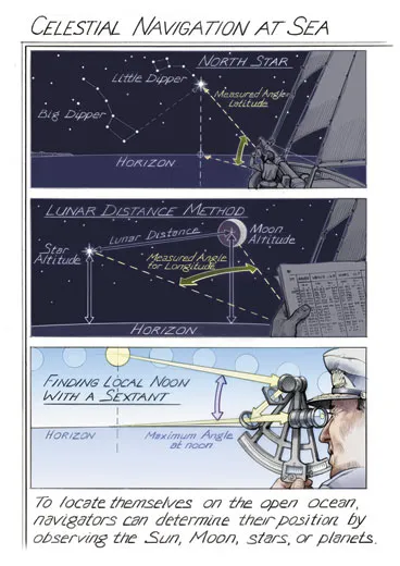
Weems used most of the lessons to teach Lindbergh how to find his position by shooting the sun with a very rare sextant. It was a 1924 Bausch & Lomb model, of which only six were made, and Weems believed it was still the best model available in the United States. Bubble sextants had been around for more than a decade, but because so little attention had been paid to aerial navigation, their design had not advanced much. During his sessions with Lindbergh, Weems carefully studied the sextant’s deficiencies, later taking his notes to the National Bureau of Standards, which worked with Bausch & Lomb to produce an improved version that saw wide service in the 1930s.
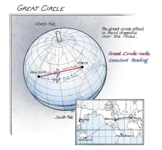
Another Weems innovation used in Lindbergh’s training was the Star Altitude Curves, a revolutionary set of charts that let a navigator find his position using two stars (one was usually the North Star, Polaris). The graphs helped cut the calculation time from 15 minutes to 40 seconds. During the day, instead of triangulating position using two stars, a navigator could use the sun to determine a line of position. By measuring the angle between the horizon and the location of the sun on its daily path, a navigator could draw a line on the globe and be assured that his position was a point somewhere on that line.
In Line of Position, Weems published the ultimate Cliffs Notes for this more difficult calculation. Though Lindbergh had dropped out of college to fly, he proved to be an excellent student and “toiled cheerfully for days over head-splitting mathematics,” Weems noted in a letter to a friend. “Lindbergh makes a fine student. He [studies] till twelve or one o’clock and does not get ‘fussed’ or rushed.” During a visit to New York, Weems stayed with Lindbergh to spend extra time tutoring, but found that he “didn’t really do much instructing”; the pilot “was brilliant and caught on quickly. He instructed himself.”
Weems and Lindbergh took a series of flights together in May 1928 in a Ryan Brougham given to the pilot by Benjamin Franklin Mahoney, owner of Ryan Airlines (the San Diego company that built the Spirit). The first flight was from Bolling Field in Washington, D.C., to Long Island’s Curtiss Field. Even with Weems’ innovations, celestially navigating while flying was a two-person job. Weems did the calculations, though he noted, “Lindbergh flew his ship with one hand and took a sextant altitude of the sun with the other! I am confident that this was the first time in history such a thing had ever been done.” But Weems’ system was still a work in progress: He noted that Lindbergh’s accuracy in this walking-and-chewing-gum mode could be off by as much as 15 or 20 miles. Shooting the sun next to the pilot, however, Weems was eventually able to fix position to an accuracy of three miles—a margin of error unacceptable today, but the position was certainly good enough to put a pilot within sight of an island.
After stopping in New York, the pair headed to Detroit to meet Henry Ford. Although Lindbergh never made the around-the-world flight, his lessons were not in vain. He helped establish cross-country air routes for Transcontinental Air Transport (known as the “Lindbergh Line” and later as TWA), and was also courted by Juan Trippe of Pan American Airways to establish transatlantic air routes. Because the continental United States was covered by a network of radio beacons, celestial navigation had little application there, but the method became essential for the overseas routes that Trippe was eyeing.
Lindbergh was a remarkably good sport about the publicity over his shortfall in navigational knowledge, and was willing to have Weems draw attention to it—even allowing his Paris navigation to be described as “little more than the automobile tourist” following street signs. The press coverage of Lindbergh’s lessons, along with his ringing endorsement, allowed Weems to launch an aerial navigation consulting business while he was still serving at sea aboard a Navy oiler. The two men kept up a close exchange on navigational questions over the next decade, including collaborating on a variant of the Second-Setting watch, which converted time to arc, the 360 units in which the globe is marked. The improved Lindbergh Hour Angle watch, as it was marketed, helped speed up one of the many calculations with which a navigator was tasked.
With Lindbergh as its first disciple, the Weems System of Navigation quickly attracted a broad range of aviators who were eager to learn the latest techniques. Armed with a set of tools, including the bubble sextant, the Second-Setting watch, and celestial plotting forms for making calculations from the Star Altitude Curves and Line of Position books (and by the mid-1930s, an Air Almanac, Lunar Ephemeris for Aviators, and a Mark II plotter—which every student pilot still receives today), Weems’ pupils now had everything they needed to find their position while in flight. One of the first clients was Australian navigator Harold Gatty, whom Weems quickly hired as chief instructor at his new school in San Diego, California, the first dedicated to air navigation. The two collaborated on numerous advances in navigation, including the Gatty Drift Meter, used to measure an aircraft’s drift from a track. Gatty taught Anne Morrow Lindbergh the Weems system. When Charles Lindbergh took Trippe up on his offer and began planning overseas survey flights for Pan American in a Lockheed Sirius, he realized that his wife Anne would have to assist with navigation. Gatty proved to be an excellent instructor. Lindbergh wrote to Weems that “we used one of your sextants and a great deal from your System of Navigation on our last transcontinental trip [April 1930]. Mrs. Lindbergh took all of the sextant readings in addition to working them out and doing most of the navigation.”
These flights were textbook examples of the Weems System. In fact, Weems became the Lindberghs’ official chronicler for the 1933 airline survey flight and used it as a case study for his Air Navigation textbook. In stark contrast to what happened on the Paris flight six years earlier, on the survey flight, the Lindberghs, carrying nearly the full suite of Weems navigation products, were able, almost without exception, to find their position.
Lindbergh and Gatty spread the Weems System through much of the aviation community in the United States and elsewhere. Gatty persuaded Lindbergh to bring Pan Am on as a client for the Weems System. The military services lacked enough instructors to train cadets for World War II, so Pan Am’s school served as a leading source of navigators for the Army Air Forces and Royal Air Force at the start of the war. In 1932, Gatty became chief navigation advisor to the Army Air Corps Frontier Defense Research Unit, which developed the service’s first viable navigation techniques for long-range strategic bombers. (One of Gatty’s first students was the architect of air power and later chief of staff of the U.S. Air Force, Curtis LeMay.) American Airlines and TWA also adopted the Weems System in the late 1930s as they began considering transatlantic routes. About the only entity not heavily influenced by Weems was his own branch of the service, the Navy. Focused on carrier-based aviation, in which celestial navigation was of little value, the service largely ignored the needs of its long-range patrol squadrons until the late 1930s, when it had to race to catch up.
For many decades, the Weems System was the principal means of fixing position in over-water navigation for the U.S. military and airlines, along with many of the famed record setters and endurance fliers. In 1937, the astounding transpolar flights that the Soviet Union achieved in Tupolev ANT-25s were made by aviators who were using the Weems System; U.S. observers noted that the Soviet aircraft had a hand-copied version of Weems’ Star Altitude Curves on board.
Lindbergh’s training was also the model for a great number of aeronautical celebrities who sought out Weems for personal instruction and guidance, including Richard Byrd, Howard Hughes, and Amy Johnson, Britain’s pioneering female aviator of the time. Weems tried to entice Amelia Earhart into training several months before departure on her ill-fated around-the-world flight with Fred Noonan, who, as Pan Am’s master navigator, had been an early student. Earhart’s husband, G.P. Putnam, declined, stating she was too busy.
Weems continued to be fascinated by navigational problems throughout his life. He collaborated with Ed Link to develop the Celestial Navigation Trainer, part flight simulator and part planetarium, which trained many World War II navigators. Awed, like the rest of the world, by Sputnik and the dawn of the Space Age, he began to adapt his aerial navigation techniques for the unique challenges of orbital mechanics; the adaptations were put to use in the Apollo program. Weems also founded the Institute of Navigation, which is still the leading professional society devoted to the advancement of navigation.
The mariner whose navigation pursuits started out as an annoyance to his superiors spent the rest of his career changing the way pilots fly around the world and in space. Weems created a community of aerial navigation experts and practitioners where none had existed. And if Lindbergh hadn’t been a good enough pupil to absorb Weems’ new techniques and a humble enough man to let his experience serve as an example to other aviators, professional standards of aerial navigation would have taken longer to develop, with a cost in lives lost and flights unmade.
Roger Connor is co-curating the National Air and Space Museum’s Time and Navigation exhibit.