The Route: Iowa City to North Platte
Pilots flying the mail cross-country in 1921 followed these directions to find landmarks along the way.
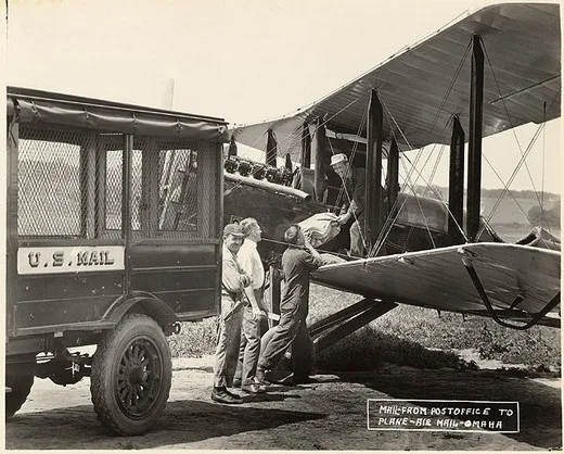
/https://tf-cmsv2-smithsonianmag-media.s3.amazonaws.com/filer/omaha-SI-89-12152~A.jpg)
U. S. Air Mail Service
Pilots’ Directions (February 1921)
191. Iowa City, Iowa—On the eastern bank of the Iowa River. The Chicago Rock Island & Pacific has four lines running out of Iowa City. The air-mail field is south of town and on the western bank of the river. The field is small and is longer east and west.
215. Chicago, Milwaukee & St. Paul Railway.
233. Chicago & North Western Railway.
240. Montezuma—Directly on course on Minneapolis & St. Louis Railway.
249. Minneapolis & St. Louis Railway.
253. Minneapolis & St. Louis Railway.—Short line.
255. Minneapolis & St. Louis Railway.
271. Monroe—Slightly south of course on Chicago, Rock Island & Pacific Railroad. Three lines out of this town.
296. Des Moines—Five miles north of course. Largest city near course between Iowa City and Omaha. Keep the Raccoon River in sight until about 18 miles out. From here on keep the Chicago, Rock Island & Pacific in sight. This railroad follows the direction of the Raccoon River for this distance. The Chicago, Rock Island & Pacific is 2 to 7 miles north of the course.
368. Atlantic, Iowa—Three miles north of the course on the Chicago, Rock Island & Pacific Railway. At Atlantic the railroads branch in five directions. If on the course at this point, that is, 3 miles south of Atlantic, fly nearly due west until Council Bluffs is seen.
413. Council Bluffs, Iowa—Five miles east of the Missouri River.
418. Missouri River, which is very irregular in its course and width at this point.
424. Omaha, Nebr.—Field is west of city and can be identified by large hangar with white circle and cross on roof. North of field is large race track and grandstand. There are two good approaches, from north and west.
Omaha to North Platte
Miles
0. Omaha, Nebr.—The air mail field is on the western outskirts of the city, and is 5 miles west of the Missouri River. The field is rectangular, the long way of the rectangle being east and west. On the north side of the field is a long grand stand facing northward and extending east and west. To the north of the grand stand is a large field with an elliptical race track in it This race track is an excellent landmark, and the oval may be used for landing if necessary. The west side of the mail field is bounded by a brook, a few trees, and a railroad track. On the south the field is bounded by a paved road which ends to the eastward at the Missouri River. This same road runs due west for several miles beyond the mail field. On the south side of the field are some high trees and a few telephone poles. A private hangar is situated across the road from the air mail field with the word “Airdrome” painted on the roof. The air mail hangar is located in the southeast corner of the field. The east side of the field is bounded by two steel wireless towers and a hill covered with high trees. From the northwest is the best approach, although landings can be made from any direction if made into the wind.
20. The Platte River is crossed at right angles by flying due west from the Omaha field. By noting section lines the pilot can determine the correct compass course correcting for drift, as North Platte and Cheyenne are almost due west of Omaha. For a distance of 70 miles the Platte River is north of the course never at a greater distance than 10 miles. The Platte River should be crossed between two bridges, one 2 miles north and the other 2 miles south of the course.
21. Yutan—Directly on the course 1 mile west of the Platte River, 5 lines of railroads form a junction at this point.
33. Wahoo—A fair-sized town 3 miles south of the course. Six railroads radiate from Wahoo. An excellent emergency landing field is located one-half mile south of Wahoo; a smooth barley field approximately 1 mile long and a quarter of a mile wide. By noting section lines and flying 25 miles west for each mile south, a direct course may be maintained.
59. David City—A quarter of a mile north of the course. Six railroads radiate from this city also.
82. Osceola—Four miles south of the course. The Union Pacific tracks almost parallel the course from David City to Osceola, where they turn to the southward. Osceola may be identified by a mile race track just south of the town.
96. The Platte River is crossed again and runs southwestward. The Union Pacific Railroad is crossed just beyond the Platte River a half a mile north of the small town of Clarks. Twelve miles southwest is Central City on the Union Pacific Railroad. This city is 7 miles south of the course. Central City is directly east of North Platte. If the pilot passes directly over this city, the east-west section lines can be followed directly into North Platte. Thirty-five miles southwest of Clarks is Grand Island in a direct line with Central City. Grand Island is 20 miles south of the course. At Grand Island there is a commercial flying field where supplies of oil and gas may be purchased.
132. St. Paul, directly on the course.—Ten miles east of St. Paul one branch of the Chicago, Burlington & Quincy Railroad runs directly west to St. Paul and lies on the course. Five railroads radiate out of St. Paul. The Middle Loup River is crossed 1 mile east of St. Paul.
161. Loup City—Is 5 miles north of the course on the east bank of Middle Loup River, which is crossed almost due south of Loup City. The Union Pacific Railroad paralleling the river is crossed 1 mile east of the river.
176. The Chicago, Burlington & Quincy Railroad tracks following a tiny stream are crossed. The railroad runs northwest-southeast at this point.
183. Mason City—On the Chicago, Burlington & Quincy Railroad; is 2 miles north of the course.
216. The Union Pacific Railroad, running northeast-southwest, is crossed midway between Lodi and Oconto; Lodi to the north and Oconto to the south. A small creek runs through Oconto which distinguishes it from Lodi.
248. North Platte—After crossing the Union Pacific Railroad no distinguishing landmarks are available, but flying west the Platte River will be seen to the south, gradually getting nearer to the course. The city of North Platte is located at the junction of the north and south branches of the Platte River. The field is located on the east bank of the north branch about 2 ½ miles east of the town, just 100 yards south of the Lincoln Highway Bridge. Another bridge, the Union Pacific Railroad bridge, crosses the stream a mile farther north. The field is triangular with the hangar at the apex of the triangle and on the bank of the river. The field, which is bounded on the southwest by the river bank and on the north side by a ditch, has an excellent turf covered surface always in a dry condition. The field is longer east and west and the best approach is from the end away from the hangar. Cross field landings should not be attempted near the hangar, as the field is narrow at this point. The altitude of North Platte is 2,800 feet or about 2,000 feet higher than the Omaha field.
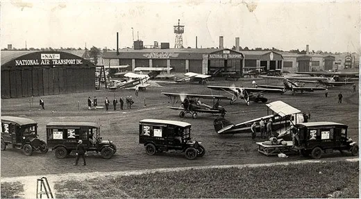
/https://tf-cmsv2-smithsonianmag-media.s3.amazonaws.com/filer/01.-SI-75-7024~A.jpg)
Sept. 10 – Depart New York Republic field (FRG) 9:30AM. Arrive Belafonte, PA. (N96) late morning. Depart and arrive Cleveland (BKL) late afternoon, early evening. Overnight stop.
Sept. 11 – Depart Cleveland (BKL) 9:30AM. Arrive late morning Bryan, Ohio (OG6). Depart and arrive Chicago Lansing Airport (IGQ) late afternoon. Arrive early evening Iowa City (IOW) Overnight stop.
Sept. 12 – Depart Iowa City 9:30AM. Arrive Omaha, NB (OMA) late morning. Depart and arrive North Platt NB(LBF) late afternoon. Overnight stop.
Sept.13 – Depart North Platt, NB 9:30AM. Arrive late morning Cheyenne, WY (CYS) Depart and arrive mid afternoon Rawlins, WY (RWL). Depart and arrive Rock Springs, WY (RKS) early evening. Overnight stop.
Sept.14 – Arrive late morning Salt Lake # 2 (U42). Depart and arrive Elko, NV (EKO) late afternoon. Depart and arrive Reno, NV (RNO) early evening. Overnight stop.
Sept. 15 – Depart Reno, NV 9:30AM. Depart and arrive Hayward, CA (HWD) late morning. Depart Hayward, CA mid day for SFO or Chrissy Field to be determined and return to Hayward, CA. R. Davies