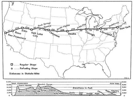
The Route: Rock Springs to Reno
Pilots flying the mail cross-country in 1921 followed these directions to find landmarks along the way.
/https://tf-cmsv2-smithsonianmag-media.s3.amazonaws.com/filer/elko-SI-85-6459~A.jpg)
U. S. Air Mail Service
Pilots’ Directions (February 1921)
231. Rock Springs—After passing Black Butte, Pilot Butte will be seen projecting above and forming a part of the Table Mountain Range. This butte is of whitish stone. Head directly toward Pilot Butte and Rock Springs will be passed on the northern side. The field is in the valley at the foot of Pilot Butte about 4 miles from Rock Springs. It is triangular in shape, the hangar being located in the apex. The surface of the field is good. The best approach is from the eastern side.246. Green River—Follow the Union Pacific double-tracked railroad from Rock Springs. There is an emergency field here which is distinguished [on] account of its being the only cleared space of its size, near the town. Green river is crossed immediately after the city of Green River is passed. Here the course leaves the railroad which continues in a northwesterly direction. By flying approximately 230˚ compass course from here, Cheyenne [Salt Lake City] will be reached.
258. Black Fork River—A very irregular river, which is crossed at right angles. From Black Fork to Coalville the Union Pacific tracks are from 5 to 20 miles north of the course.
282. Granger—16 miles north of the course on the Union Pacific where the Oregon Short Line joins the Union Pacific from the north.
330. Altamont—On the Union Pacific where the Union Pacific approaches within 6 miles of the course to the north. The railroad passes through a short tunnel at this point.
338. Evanston—After approaching within 6 miles of the course, the railroad turns sharply to the northwest. Evanston is on the Union Pacific 18 miles north of the course. There is a good emergency landing field on the southwest side of Evanston, a mile from the railroad station. From Evanston the Union Pacific tracks curve toward the course until Coalville is reached.
363. Coalville—On the single track Union Pacific running north and south. The single track Union Pacific joins the double track 4 miles north of Coalville at Echo City. There is an emergency landing field here a mile east of the railroad and one-half mile southeast of town. There is a marker on this field.
381. Salt Lake City—From Coalville the country is extremely rugged and the pilot should maintain at least 11,000 feet altitude above sea level. The field lies 2 miles west of the city on the north side of the road or street which extends east-west by the Salt Lake fair grounds. Locate the fair grounds, identified by an elliptical race track and large buildings. Follow westward along the road just south of the fair grounds and the field will be reached 1 ½ miles farther on. The field is about one-half mile long north and south and landings are usually made in one of these directions. A landing T is used to indicate the proper place to land. Elevation here is 4,400 feet. High-tension wires border all sides of the field except the north.
Salt Lake City to Reno
Miles
0. Salt Lake City—Fly west from Salt Lake, keeping the two railroads running due west from Salt Lake to the south.
12. Saltair—Near the salt works there is an open field which is possible for an emergency landing. The field lies between the highway and the electric railroad that runs into Salt Lake City. Is rolling and covered sparsely with sagebrush and should be used only in case of absolute emergency.
14. Antelope Island—In the Great Salt Lake, 6 miles north of the course.
30. Stansbury Island—In the Great Salt Lake. The course crosses this island about 2 miles from its southern edge.
45. The Union Pacific Railroad is crossed where it runs northeast-southwest. Two miles north of the course the railroad makes a sharp bend and runs southeast-northwest.
50. The Union Pacific Railroad is crossed again. The Union Pacific continues southeast from here for 10 miles and then turns westward and parallels the course to Wendover. The course is 6 miles north of the railroad.
98.Salduro—On the Union Pacific Railroad, 6 miles south of the course. There is an emergency field here in vat No. 5, marked by a black T. The vat is circular, 400 feet in diameter and the bottom, composed of white salt, is hard as a pavement.
108. Wendover.—On the Union Pacific, 6 miles south of the course. Opposite the Conley Hotel and the Union Pacific station there is a landing field L-shaped, 1,200 feet long each way and 600 feet wide, a good emergency field. Four miles west of Wendover the Union Pacific Railroad turns to the north and east and is crossed 8 miles west of Wendover. The railroad continues northwestward and reaches a northern point 11 miles from the course. The railroad curves and runs southeast, where it crosses the Nevada Northern, running north-south at Shafter.
130. Shafter—At the junction of the Nevada Northern and Western Pacific Railroads. Opposite the Western Pacific station at Shafter there is a stretch of ground 1,200 feet wide and unlimited in extent the long way, that may be used for emergency landings. There is a scattering of sagebrush on this field.
145. The Western Pacific Railroad is crossed, running northwest-southeast, after it makes a loop to the south just beyond Shafter. The railroad veers to the north until it is 20 miles north of the course.
157. Snow Water Lake—An oblong body of water 3 miles south of the course. The long way of the lake extends parallel to the course.
170. Secret Pass in the East Humboldt Range—The only pass in this range for many miles. Some peaks in this range attain an altitude of more than 12,000 feet. The northern extremity of the Ruby Range extending north and south lies a few miles south of the course and is next seen. Then three branches of Tamoville Creek flowing north to the east fork of the Humboldt River are crossed at short intervals. The Southern Pacific and Western Pacific Railroads follow the course of the east fork of the Humboldt River and gradually converge on the course where all four join at Elko.
204. Elko—Lies in the Humboldt Valley. The air mail field is 1 mile west of the city, with the main runway east and west. Landings may be made from any direction, although it is advisable to land east and west. There is a ditch at the east end of the field. Follow the general direction of the railroad tracks out of Elko, as they run parallel with the course for several miles.
224. Carlin—Between the Western Pacific and the Southern Pacific Railroad tracks, 1 mile south of the course.
238. Harney—Six miles south of the course, midway between the cities of Palisade and Beowawe on the Southern Pacific and Western Pacific Railroads. South of the railroad tracks here is an emergency field 1,500 by 900 feet, with a shallow ditch in the center running across. Landings can be made safely across this ditch. There is a ranch house in one corner of the field. A narrow gauge railroad runs south from Palisade, a town 7 miles east of Harney.
246. The course crosses the Western Pacific and Southern Pacific Railroad tracks. Up to this time the railroad tracks have been on the south of the course, but from now on the two railroads are to the north.
268. Battle Mountain—At the junction of the Southern Pacific and the Nevada Central Railroads, 8 miles north of the course. Battle Mountain lies in a valley surrounded on the east and west by high ranges. Here will be found an excellent landing field laid out in the form of an ellipse, marked with a T and a wind-indicator. The field lies directly west of town. All types of supplies for servicing may be found here. From this point the railroads turn north and west and leave the course almost at right angles.
278. The Nevada Central Railroad is crossed 12 miles southwest of Battle Mountain. From here on for the next 100 miles the course lies over uninhabited and desert country.
293. Alkali Lake—Lies on the northern edge of the course.
363. Humboldt Lake—The course adjoins the southern edge of this lake and crosses the Southern Pacific Railroad 5 miles beyond. If the pilot elects to not fly the direct course, the Southern Pacific Railroad may be followed from Battle Mountain to Winnemucca, a distance of approximately 60 miles. At Winnemucca is an emergency field south of town, marked by a wind indicator and a T. Supplies necessary for reservicing a ship may be obtained here. At this point the Western Pacific continues on in a westward direction, while the Southern Pacific turns to the southwest. Following the Southern Pacific for 30 miles the small town of Imlay will be reached. There is open unobstructed land on all sides of the town, suitable for emergency landings. Forty miles farther on will be found the city of Lovelocks. A first-class landing field is situated here on the eastern edge of the Southern Pacific tracks just south of town. A permanent T has been placed on the field and a rolled runway constructed. Gas and oil may be obtained from the Standard Oil plant on the edge of the filed, and at a near-by fertilizer plant there is a fully-equipped machine shop which is offered for the use of any pilot who may need to make repairs to his ship. This field is level and is kept up in good shape. Pilots coming in must hold the ship up with the gun until they pass over a series of irrigation ditches at the end of the field. After these ditches have been passed a landing may be made. Numerous emergency landing fields may be found all the way between Winnemucca and Lovelocks. Twenty-five miles farther on the Southern Pacific joins the course 5 miles east of the southern edge of Humboldt Lake, into which the Humboldt River empties. To the south of Lake Humboldt is Carson Sink, which has a dry sandy bottom throughout the year and offers an ideal landing ground, but is uninhabited and pilots can not receive assistance except along the railroad. By following the Southern Pacific Railroad from Humboldt Lake southward for 25 miles, Hazen, Nev., will be reached.
388. Hazen, Nev.—Fourteen miles south of the course on the Southern Pacific Railroad. Four branches of this railroad radiate out of Hazen. All about the town there are open fields of a size sufficient to set down an airplane. The best landing field is to the south and east of the Southern Pacific roundhouse and is a space a mile long and half a mile wide. Sagebrush grows on the eastern portion of this field and the southern end is bounded by a set of high-tension wires. A 40-foot T marks the field. If the pilot has flow as far south as Hazen he can follow the Southern Pacific westward into Reno. If he is on the direct course, he will cross the northern branch of the Southern Pacific 7 miles north of where it joins the east-west main line at Fernley. Twelve miles to the north Pyramid Lake can be seen.
437. Reno, Nev.—The air mail field at Reno lies 2 miles west of the city. The main runway is east and west. The field is marked by a T and wind indicator, and landing from four ways is unobstructed. Reno is 4,497 feet above sea level. Whenever possible it is advisable to leave the Reno field on the east-west runway, taking off to the east. A slight downgrade enables the ship to quickly obtain flying speed. Just beyond the east edge of the field the ground is extremely rough and there is a huge ditch here.
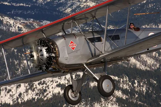
/https://tf-cmsv2-smithsonianmag-media.s3.amazonaws.com/filer/01.-SI-75-7024~A.jpg)
Sept. 10 – Depart New York Republic field (FRG) 9:30AM. Arrive Belafonte, PA. (N96) late morning. Depart and arrive Cleveland (BKL) late afternoon, early evening. Overnight stop.
Sept. 11 – Depart Cleveland (BKL) 9:30AM. Arrive late morning Bryan, Ohio (OG6). Depart and arrive Chicago Lansing Airport (IGQ) late afternoon. Arrive early evening Iowa City (IOW) Overnight stop.
Sept. 12 – Depart Iowa City 9:30AM. Arrive Omaha, NB (OMA) late morning. Depart and arrive North Platt NB(LBF) late afternoon. Overnight stop.
Sept.13 – Depart North Platt, NB 9:30AM. Arrive late morning Cheyenne, WY (CYS) Depart and arrive mid afternoon Rawlins, WY (RWL). Depart and arrive Rock Springs, WY (RKS) early evening. Overnight stop.
Sept.14 – Arrive late morning Salt Lake # 2 (U42). Depart and arrive Elko, NV (EKO) late afternoon. Depart and arrive Reno, NV (RNO) early evening. Overnight stop.
Sept. 15 – Depart Reno, NV 9:30AM. Depart and arrive Hayward, CA (HWD) late morning. Depart Hayward, CA mid day for SFO or Chrissy Field to be determined and return to Hayward, CA. R. Davies