Keep Watching the Ice
Meet the satellites bringing data to the discussion of global warming
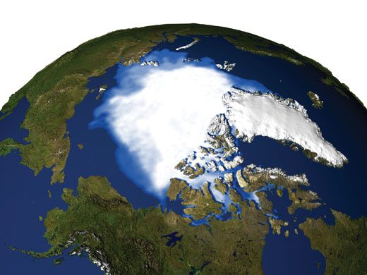
/https://tf-cmsv2-smithsonianmag-media.s3.amazonaws.com/filer/ice-388-sept06.jpg)
IN EARLY MAY, WHEN MOST PEOPLE in the United States enjoy the warm days of spring, veteran NASA glaciologist Jay Zwally instead heads north to the ice-bound edge of western Greenland.
It takes two aircraft, an LC-130 transport and a de Havilland Twin Otter, to get him to a collection of tents pitched on a wooden platform, known by glaciologists as the Swiss Camp. The name is a remnant of its origins as a research site operated by a Swiss university, now used by NASA and others to measure the effects of climate change.
Just south of the camp lies the Jakobshavn Glacier, a thick slab of ice that is gradually sliding downhill toward the Greenland coast. At the water’s edge it becomes the Jakobshavn Isbrae, a tongue of ice spilling into a natural inlet. The surface of the glacier melts in the summer, and Zwally needs to prepare his Global Positioning System sensors in the ice to measure how the surface water affects the glacier’s velocity.
When Zwally is not on the glacier, he’s in Maryland running the science side of a $283 million NASA satellite project that is watching it. Whether deploying equipment on the ice or into orbit, he is seeking data to answer some of the thorniest questions in the debate over global climate change: How quickly will Earth’s ice melt as the planet continues its expected warming trend, and what will the extra water do to sea levels?
In the community of glaciologists, Zwally’s training as a mechanical engineer and physicist is unusual. As a young engineer in the 1960s, he built part of a solar wind detector that flew aboard NASA’s Explorer 34 scientific satellite. He then earned a Ph.D. in physics from the University of Maryland but couldn’t find a job in that field. “I got this wonderful opportunity to go to the National Science Foundation and I got into glaciology, polar research,” Zwally says. In 1974, he moved to NASA, and now works at the Goddard Space Flight Center in Greenbelt, Maryland.
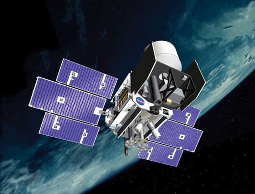
In the mid-1980s, Zwally first conceived of a satellite that could measure Earth’s ice by bouncing infrared laser pulses off Earth’s ice sheets. In January 2003, NASA launched the Ice Cloud and Land Elevation Satellite, or ICESat, with Zwally serving as project scientist. Forty times a second, ICESat fires its laser, catches the reflections with its telescope, and calculates the height of the ice based on how long it takes the signals to return.
ICESat’s altimeter data will enable scientists to calculate the volume of the ice still present in Earth’s glaciers. By comparing the measurements taken over the life of the satellite, scientists will figure out whether Earth’s glaciers overall are losing or gaining ice, and if so how much.
ICESat is one of two satellite systems NASA is counting on to make the first truly quantitative, three-dimensional measurements of the planet’s ice cover. The second system, the Gravity Recovery and Climate Experiment, or GRACE, consists of twin satellites that can sense the shrinking of ice sheets by measuring the diminishment of their gravity tug. GRACE was launched in March, 2002.
Armed with these satellite measurements, glaciologists are taking the first steps toward predicting how much ice will disappear from Earth in the coming decades—the critical figures of “how much and when,” Zwally calls them.
At the moment, water that might otherwise flood coastal cities and towns around the world remains locked away as ice, much of it in Antarctica and Greenland. “The glaciers have in them on the order of 70 meters—200 feet—of potential sea level rise,” says Bruce Wielicki, a senior scientist at NASA’s Langley Research Center in Hampton, Virginia. “No one is talking about us getting all 200 feet in the next 100 years, but the point is, even if you only got five of that 200 feet, where I live, our average elevation is about three feet. So the costs of dealing with sea level change are one of the huge potential issues.”
Initial data from GRACE has already sparked debates and some concern. “We’re seeing very quick responses to changes in temperature, responses that people used to think would take hundreds or thousands of years,” says Zwally’s boss, glaciologist Waleed Abdalati, head of the Cryospheric Sciences Branch at the Goddard Space Flight Center. “It’s not a ‘run for the hills’ kind of story, but it’s ‘Wow, this is serious.’ Things seem to be stirring in a way that is going to contribute to [an increase in] sea level.”
But there is no agreement among scientists on how quickly the sea level will rise, how quickly the global climate will heat up, or even how warm Earth might get. According to a panel of scientists who looked into the question for the Bush administration in 2001, the temperature could rise an average of 2.5 to 10.4 degrees Fahrenheit in the next 90 years.
What is certain, even among scientists who have criticized their colleagues for over-hyping global warming, is that at least some of Earth’s warming is due to a buildup of carbon dioxide from the burning of fossil fuels. These gases trap heat from the sun, resulting in the greenhouse effect. The main disagreement is over the urgency of the problem.
“This issue is not going to come and kill us all, despite the apocalyptic renditions you see in newspapers,” says University of Virginia climatologist Pat Michaels, whose book Meltdown criticizes the methods used by most climate scientists. Michaels calculates the pace of human-caused warming to be slow enough for correction: “We have time to invest in future [energy] technologies.”
More information is needed to gauge the seriousness of the problem. If ICESat corroborates the GRACE findings, Earth’s coastlines could look dramatically different within 100 years.
GRACE is the first satellite system of its kind. It consists of two satellites that follow the same orbit about 120 miles apart, says Mike Watkins, the GRACE project scientist at NASA’s Jet Propulsion Laboratory in Pasadena, California. “This is not like the 13th mission to make the same measurement a little bit better,” Watkins says. “It’s really a revolutionary thing.”
When the lead GRACE satellite reaches a point in its orbital path above an area of increased mass, such as a mountain or ice sheet, the corresponding increased gravity tug slows it down and changes ever so slightly the distance between it and its twin. Microwave signals that are continuously passed between the two satellites now arrive at slightly different points along their wavelengths than they did before the slight disruption. GRACE’s electronics detect the change, and software measures the change in distance between the satellites to an accuracy of one micron, or a millionth of a meter.
A team of researchers at the University of Texas’ Center for Space Research in Austin converts that data into monthly maps that are color-coded to show changes in the distribution of Earth’s mass—primarily the movement of water. Other researchers use the data to explore the rate of the planet’s ice loss. Isabella Velicogna and John Wahr, satellite researchers at the University of Colorado in Boulder, wrote what is perhaps the most stunning GRACE-based report. The two examined the data and reported in the March 2, 2006 issue of Science that Antarctica is losing 36 cubic miles of ice a year. That’s enough to fill Lake Erie in three years.
The job facing Velicogna and Wahr was not quite as simple as placing the entire Antarctic ice sheet on the equivalent of a bathroom scale. Earth’s crust is still rising in some places and subsiding in others in reaction to the weight lifted by the melting of the glaciers at the end of the last ice age, more than 10,000 years ago. The scientists had to factor out the post-glacial rebound. “We use some models to remove this signal, and then what’s left is the mass change of the ice,” Velicogna explains.
Zwally doesn’t doubt that Antarctica’s ice cover is shrinking, and the effect over the centuries could be devastating, but he thinks Velicogna and Wahr have the scale wrong. “Too big a number for Antarctica,” he says tersely over the phone, while preparing to leave for Greenland. He later adds that a true accounting of ice being lost will be calibrated by ICESat, aiding scientists’ calculations of the resultant rise in sea levels.
The strength of GRACE is that it accurately measures mass, providing hard numbers for the amount of ice lost, but only on geographic scales large enough to produce a gravity tug that can be sensed.
ICESat works nothing like GRACE, which is why glaciologists are curious to see whether the findings from the two projects corroborate each other.
When Zwally started advocating for ICESat among his colleagues, he knew the potential of using altimeters to measure ice, but also saw the limits of flying them on airplanes, which was the common method. Only a satellite orbiting from pole to pole could provide the coverage necessary to monitor content across an entire continent or subcontinent. Radar satellites were on the horizon, but Zwally knew those readings would be much less precise because radar wavelengths are longer than those of laser light. “Satellite radar can’t get all the way to the edges of ice,” Zwally says. “There’s penetration too. The radar penetrates some distance into the snow. And that has some variability depending on the properties of the snow. The laser measures directly to the surface.”
ICESat measures the height of Earth’s surface every 660 feet, so it can examine relatively small features. “What ICESat can do is provide very high resolution on a particular track: What’s happening on this glacier?” says Jim Abshire, a soft-spoken native of Tennessee whose job is to ensure the accuracy of ICESat’s laser
system.
NASA had planned to run ICESat’s three lasers in sequence until they burned out—ideally after at least five years of continuous measurements. But ICESat managers were shocked when one of the lasers fizzled after just 36 days. NASA rushed to assemble a review panel headed by veteran NASA engineer Bob Kichak, an expert in spacecraft power systems, to determine what went wrong and whether anything could be done to save the remaining two lasers.
Inside each ICESat laser, dozens of half-inch-long light-emitting diodes project light onto a metallic crystal. The electrons in the crystal become so energized that they release pulses of laser light. The diodes are linked to a power supply by numerous hair-like gold wires. NASA officials disassembled a spare unit purchased from the manufacturer, Spectra Laser Diodes of San Jose, California, and examined the diodes under high magnification. Kichak’s board concluded that “excessive” amounts of metallic indium solder, used to hold the diode assembly together, had most likely contacted the gold wires and eroded them, causing a catastrophic loss of power. The most likely cause for the presence of the extra solder was a manufacturing error.
Based on Kichak’s recommendations, NASA ordered a complete overhaul of ICESat’s operating plan. To conserve the lasers, operators can turn them on only three times a year for 33-day-long “campaigns.” ICESat’s cooling system would slow any chemical erosion. Engineers eventually decided to run the lasers at a temperature of 14 degrees Fahrenheit, says Zwally.
The decision dimmed the laser’s visible, green light, so ICESat’s secondary measurements of aerosols and clouds can be gathered only at night. The ice and land elevation readings aren’t compromised because they require only the lasers’ infrared channel, Zwally says .
NASA officials breathed cautious sighs of relief as the second and third lasers were turned on and ICESat gathered data successfully. The second lasted about 100 days before officials decided to turn on the third.
Abshire says that even with initial drawbacks, the lasers have performed better than expected. Satellite-based instruments often have Achilles’ heels, and in the case of ICESat, the weakness is a slight laser-pointing error as ICESat crosses in and out of Earth’s shadow. To measure the effect, experts from the Scripps Institution of Oceanography in La Jolla, California, drove SUVs over a salt flat in the mountains of Bolivia using GPS receivers to survey the terrain. ICESat passes within range of this salt flat every two weeks, and during those passes, controllers program the satellite to turn sideways so that its laser bounces off the salt flat. By comparing those readings to the ones from the GPS receivers, scientists know that ICESat is operating with an absolute accuracy as fine as seven centimeters (2.7 inches), better than the original target of 10 centimeters, Abshire says. When mathematical models are applied to subtract the known aiming errors, the instrument has proven to make repeatable measurements with a margin of error as low as three
centimeters.
The new ICESat operating plan has made the job of steering and controlling the spacecraft more complicated for the staff and students at the University of Colorado’s Laboratory for Atmospheric and Space Physics in Boulder. LASP officials had assumed they would settle in to a pattern of routine monitoring from the lab’s cozy mission operations center. But during a teleconference in 2003, NASA managers outlined the new operating scenario to the LASP staff. “When we went to that telecon we went, ‘Whoa! They’re going to correct a manufacturing defect with an operational workaround,’ which
wasn’t unheard of,” says veteran satellite controller Jack Faber, an operations engineer who also teaches satellite control at the University of Colorado. “The bottom line was LASP is going to have to do a lot of work.”
The satellite is steered not by rockets but by electric-powered reaction wheels, which spin at differing rates to create a predictable torque that changes the direction in which the satellite points.
Since ICESat studies the changes in glaciers, volcanoes, and river basins that might be off its orbital track, LASP controllers must be ready to turn it to face targets of opportunity. Now that ICESat is run intermittently, the controllers have to work harder during the limited time. Controllers must upload aiming commands approximately once a week instead of once a month, as was the original plan.
ICESat’s laser campaigns are intense affairs in which controllers closely monitor the temperature of the laser subsystems for signs of trouble. Each time the satellite comes into range of a ground station, controllers have about 12 minutes to send commands and download the all-important temperature readings.
On one sunny afternoon at LASP, ICESat has risen above the horizon north of Alaska and into range of the Svalbard ground station in the Norwegian Arctic.
Faber and Chris Bunch, a 22-year-old mechanical engineering student, are ready to make contact with the craft, and Bunch is twirling a pen nervously in one hand.
Faber’s graying beard and jeans may look typically Boulder, but he’s anything but casual about running the operations center. He once famously booted the LASP director out of the control center for being distracting during the critical moments after a satellite launch.
“Stand by for table 29?” Bunch asks, referring to software that will pave the way for ICESat to receive the latest set of operating commands.
“Okay for 29,” replies Faber.
With the commands on their way, Faber quickly checks the status of the laser system. Among the streams of acronyms and numbers that fill his computer screen are eight circular “gumballs” summarizing the status of ICESat’s critical systems.
All eyes are on the gumball labeled “Thermal.” It has come up a happy green. If it were red, cell phones and pagers would have sounded from Colorado to Maryland as engineers got to work figuring out how to cool ICESat’s last laser before it burned out. Just to be safe, Faber checks more temperature readings. “Everything is fine,” he says.
Engineers hope to squeeze another five or six campaigns out of Laser 3, ICESat’s last fully functional laser. Despite the problems, Zwally counts the launch of ICESat in January 2003 as his biggest achievement at NASA. Still, he will be the first to say that scientists cannot rely on space-based sensors alone to answer questions about Earth’s glaciers. Sometimes they need to get close.
At the Swiss Camp, Zwally ventures out by snowmobile to drill holes in the ice and insert poles equipped with GPS receivers. As the glacier moves, the GPS units will move with it, and Zwally will record its speed.
When Zwally started this GPS research in the mid-1990s, fellow glaciologists were surprised by his results. The Jakobshavn Glacier was accelerating during Greenland’s summer months and slowing in the winter. The finding flew in the face of something glaciologists believed about glaciers.
“Ice is a very poor [thermal] conductor, so changes on the surface don’t get into the ice very fast," Zwally says. “It takes tens of thousands of years.” So how then could an entire glacier react to temperature changes that last only a season?
In considering the question, Zwally remembered flying over a glacier and watching water flowing into it from surface lakes and ponds. The water was channeled into tunnels glaciologists call moulins.
Zwally published the now widely accepted hypothesis that water flows through the moulins all the way to the bottom of the glaciers, where the water acts as a lubricant between the rock and the ice.
The faster glaciers slide downhill, the quicker they melt or break apart in the warming seas. In a 2002 paper in Science, Zwally wrote that his melt acceleration theory appears to be more than a seasonal effect. It is “a mechanism for rapid, large-scale, dynamic responses of ice sheets to climate warming,” he wrote.
More discoveries like these are expected: Glaciologists say they are just at the beginning of understanding Earth’s ice. “Until very recently we didn’t really know whether Greenland or Antarctica were shrinking or growing,” says Zwally.
Now that there is agreement that both are losing ice, it’s up to GRACE and ICESat to tell scientists exactly how much. The results may bring much-needed clarity to the continuing questions over the potential effects of global warming.