Planet Earth: A Guide for Alien Scientists
If astronomers from another world sent a probe to study ours, where would you tell it to land?
/https://tf-cmsv2-smithsonianmag-media.s3.amazonaws.com/filer/ac/fa/acfa5f86-20cf-45d6-bc25-13211f568cad/01_destination-earth_feb_14.jpg)
A fundamental problem for scientists studying the universe is that it’s big. They can’t point telescopes at every star in the sky, or send planetary rovers traversing millions of square miles, so they have to choose the best targets.
John Grant knows about choosing. A geologist with the National Air and Space Museum, he co-chaired the research committee that selected Gale Crater as the landing site for NASA’s Curiosity rover. (He did the same for the Mars Exploration Rovers Spirit and Opportunity 10 years earlier.) “There are two things you want to do when you go to a particular place on Mars,” Grant says. First, naturally, you want to make sure the site meets the mission’s scientific requirements. For Curiosity, that meant a place with many geologic layers, so the rover could study what conditions were like in the Martian past, when at least some parts of the planet were habitable. “The second thing is, you want to be able to put those results into a global framework.” Observations from Mars orbit have shown other landscapes on the planet similar to those at Gale Crater, so the rover’s limited view on the ground can be extrapolated to tell us about Mars as a whole.
That led us to wonder: If intelligent beings wanted to land a probe on Earth to learn as much as possible about our geology, what locations would reveal the most? We asked a few experts to be the aliens’ John Grant and tell us: Where is Earth’s Gale Crater?
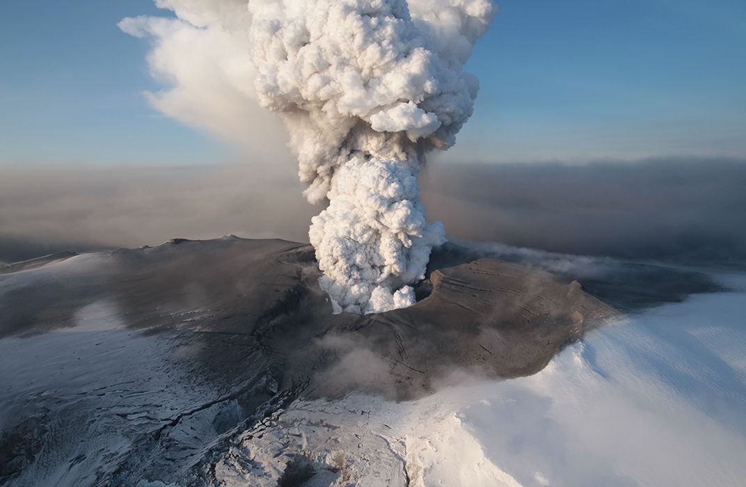
Fire and Birth: Iceland
Brent Grocholski, a postdoctoral fellow with the Division of Meteorites at the Smithsonian’s National Museum of Natural History, suggests a one-stop-shopping site for the extraterrestrial geologists. “Our planet is defined by plate tectonics, but also has volcanoes fueled by heat coming from the deep mantle,” he says. “Wouldn’t it be great if you could land someplace where you could find both an active rift zone and a volcanic hotspot? Welcome, aliens…to Iceland.”
The active rift zone here is the Mid-Atlantic Ridge, which reaches from below the southern tip of Africa along the floor of the Atlantic Ocean to southwest Iceland, where it emerges onto land. At the ridge, two tectonic plates are slowly drifting apart, creating a fissure where magma rises from the mantle and cools to form new crust. These ridges exist all over the planet, mostly underwater. In Iceland, a rover could watch this fundamental geological process from dry land.
Iceland also is one of the most volcanically active places on Earth. A rover wouldn’t have to travel far to see wide swaths of land covered in lava rock. It would find geothermal activity like hot springs and fumaroles—holes in Earth’s crust emitting superheated water that turns to steam and often reeks of sulfurous gas belched up from below. Navigating the rough ground might be tricky, but the rover would be able to explore fissures, craters, and calderas formed from the constant movement of magma under the ground. It might even catch an eruption in progress: Iceland has one every few years.
If the probe landed near Breiðafjörður, a large, shallow bay on Iceland’s western coast, the aliens could even learn something about astrogeology. Watching the tides go in and out over the course of a day would reveal the physical relationship between Earth and its moon.
The Depths: Mariana Trench
The first thing alien astronomers are sure to notice when observing Earth from afar is that our pale dot is distinctly blue, says Deborah Hutchinson, a marine geologist with the U.S. Geological Survey. So a list of potential landing sites almost certainly should include one that involves a splashdown. But, she asks, “Do you want to go to where the extremes are, or is there more value in going to something that’s more representative?” Hutchinson says that extreme places can actually offer broader insights: The features are more obvious, the results are more dramatic, and they give you one endpoint to use for calibration.
Therefore, we wouldn’t want aliens to target just any place in the ocean. Perhaps the best location would be over the Mariana Trench. The deepest point, the Challenger Deep, is about 200 miles southwest of Guam, in the western Pacific Ocean. Though the trench isn’t visible from the surface, aliens could find the underwater canyon by using gravity mapping, Hutchinson says, the way NASA’s GRAIL spacecraft recently mapped the moon. Space-faring aliens would likely have the technology to deal with the pressure their probe would have to withstand at a depth of 36,000 feet: eight tons per square inch.
“My experience is that nature doesn’t usually operate in long, linear features,” Hutchinson says. In other words, in gravity maps, the ocean trenches should stand out. Studying the trench, the visitors would learn what causes those long features: plate tectonics. The massive trench is the result of two plates converging in the subduction zone where the large, heavy Pacific plate is sliding slowly under the smaller, lighter Mariana plate. Learning how the plates move and how the movement creates trenches, volcanoes, mountains, and earthquakes would teach the aliens a lot about Earth’s geophysics.
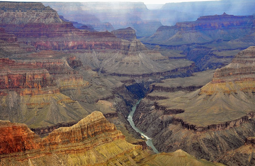
The Power of Water: The Grand Canyon
A rover sent to study Earth’s geological history would do well to visit Arizona’s Grand Canyon, where the Colorado River has slowly, over millions of years, carved a slice through the planet’s crust. “If aliens were to land here, they would see a wonderful layer cake of Earth history,” says Richard Murray, professor of Earth sciences at Boston University.
Karl Karlstrom, a geologist at the University of New Mexico who has spent his career studying the canyon, calls it “one of the most spectacular and informative geological laboratories on Earth.” The first thing a visitor will see is how powerfully water changes the landscape. The Colorado River drains a huge area of the western United States, so “a visit here would provide information about water-driven erosion at the scale of half a continent,” he says. It would also show that different types of rock have different degrees of resistance to erosion. Not even a volcano can stop the water for long. “Lava dams formed several times over the last half-million years when volcanoes erupted on the rims,” says Karlstrom. “But each dam was quickly [over thousands of years] eroded by the not-to-be-harnessed river.”
A trip down into the mile-deep canyon would be a journey back through nearly half of Earth’s 4.5-billion-year history. The canyon floor has veins of pink granite made from cooled and hardened magma that rose to the surface when the North American plate collided with an island chain about two billion years ago. Moving up the canyon walls from the floor, sedimentary rock shows that the area was covered by a shallow ocean about 500 million years ago. Each layer tells more of the story, from the iron-rich sandstone formed from a muddy coastal plain about 280 million years ago (the iron gives the canyon much of its reddish color) to the limestone in its topmost layer, which is more than 250 million years old.
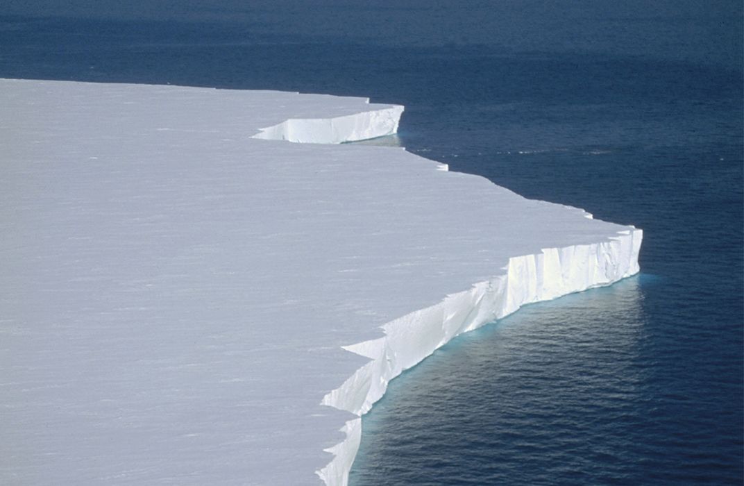
History on Ice: Antarctica
Studying an ocean trench or volcano would teach extraterrestrials that Earth’s crust is continually moving, and that this movement forms many of our planet’s most conspicuous features. But if they land their probe on an ice sheet, they’ll get a slice of history.
Cin-Ty Lee, a Rice University geochemist and petrologist who calls himself a “natural historian of the Earth,” would send a rover to an ice shelf, like Greenland or Antarctica’s Ross Ice Shelf, not far from where the U.S. McMurdo research station is located. There, a rover outfitted with proper equipment could drill down to the base of the ice sheet. An ice core sample, Lee says, is “like a tape recorder of the planet.” The thick sheets are created over millions of years, as snow and sleet falls, carrying samples of the atmosphere with it. The snowfall is gradually compacted, forming discrete layers as the seasons change. Analysis of contaminants in the layers can reveal when a volcano erupted. Trapped bubbles can show the amounts of oxygen, carbon dioxide, and other gases in the atmosphere over time, and water isotopes are evidence of temperature changes.
Given enough time to look around, the rover would discover that the ice shelf is holding back enormous glaciers, which otherwise would slide rapidly toward the sea. The aliens “would recognize how glaciers dramatically transform landscapes over thousands of years,” says the Smithsonian’s Brent Grocholski. A clever alien scientist might notice that glaciers come in two main types: Alpine, which forms in mountains, and continental—large unbroken sheets. Both can be studied in Antarctica.
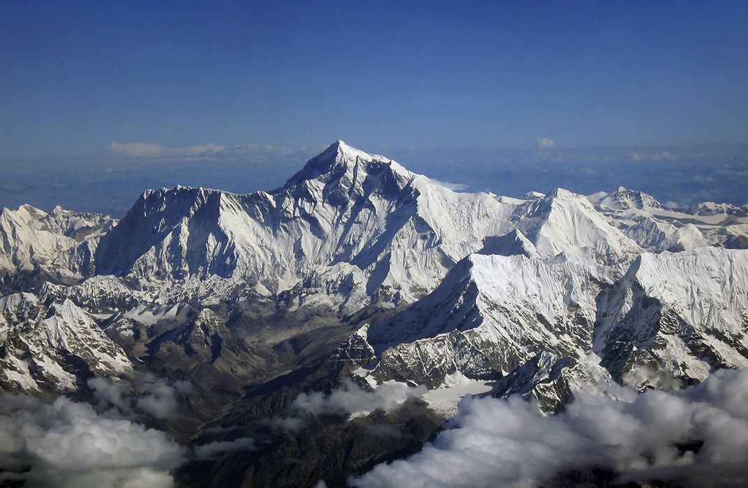
The Heights: Everest
Having pointed our extraterrestrials to Earth’s deepest spot, should we also send them to the tallest peak? In fact, 29,029-foot-high Mount Everest, part of the Himalayan range in Asia, would reward any spacefaring geologist.
“As the point of highest elevation on the planet, it is natural that any alien may want to land there,” says Richard Murray. But our visitors don’t even need to land on the summit. Anywhere in the vicinity of Everest, aliens would see dramatic evidence of Earth’s tectonic plates plowing into each other. Unlike the Mariana Trench, where a heavier plate is burrowing under a lighter one, the Himalayas were created 40 million years ago when two light plates, the Indian and Eurasian, crunched together, pushing the land upward. If the alien probe stayed around to take occasional altitude measurements, it would detect that these already tall mountains are getting even taller, by almost an inch a year.
What if the rover did land at the summit? “The aliens may be a bit confused,” says Murray, “because Mount Everest includes fossils from shallow seas.” Before the land rose, the Tethys Sea sat between the two colliding landmasses, and because its sea floor is made up of light rock, the collision produced mountains instead of a trench. About 20 million years after the range began to form, the water dried up, but the remains of long-dead sea creatures continued to rise. “The visitors may wonder why fossils would be found so far above sea level,” Murray says, “but if they knew what was going on, it would certainly tell them how geologically active our planet is.”
Maybe it’s too much to expect that alien geologists could figure all of this out based on visiting just five locations. After all, it’s taken our own scientists centuries to begin to understand Earth as a planet, and they live here. But at least it’s a start. And, as any of our experts would attest, there’s still plenty left to explore.