The Red Album
Mars’ foremost photographers pick their favorite images of their favorite planet.
Asked to nominate one place as Mars’ branch office on Earth, you could come up with a short list of candidates: NASA’s Jet Propulsion Laboratory in California, where most Martian spacecraft are built; the University of Arizona, which just ran the Phoenix lander mission from its Tucson campus; Ray Bradbury’s house.
Less well known, but every bit as Mars-centric, is the San Diego headquarters of Malin Space Science Systems, where planetary scientist Mike Malin and his colleagues build instruments for exploring the Red Planet. Most of the spacecraft sent to Mars in the past decade have had one of the company’s cameras on board, and the number of images added to NASA’s archive as a result has reached well over 260,000.
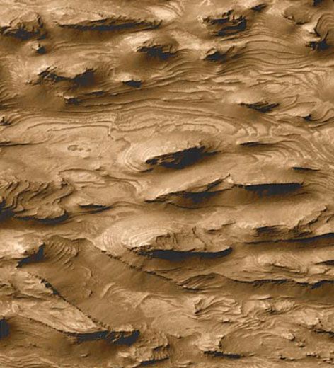
We asked Malin and his colleagues to pick some of their favorites, which you can browse in the gallery at right. Among them is this widely reproduced image of layered outcrops in West Candor, one of the canyons of Valles Marineris. Taken in 1999, early in the primary mission of the Mars Global Surveyor, the photo above was one of the first to show hundreds of layers in the canyon, suggesting a more complex geological history than scientists had expected. Just one of the many surprises and delights from the Malin collection.
Wide Angle Mosaic
/https://tf-cmsv2-smithsonianmag-media.s3.amazonaws.com/filer/redalbum-1.jpg)
This mosaic of wide angle images from the Mars Observer Camera (MOC) on NASA's Mars Global Surveyor (MGS) spacecraft was taken on May 24, 2002. The picture shows the planet's north pole in springtime, with dust storms visible near the edge of the polar cap. The heat differential between this cold ice cap and the warmer rocks to the south create winds that kick up dust storms each northern spring.
Fossil Delta
/https://tf-cmsv2-smithsonianmag-media.s3.amazonaws.com/filer/redalbum-3.jpg)
This MOC view of a long-dry, "fossil" delta in Eberswalde Crater was the smoking gun that established unequivocally the existence of persistent—as opposed to sporadic—water flow in the Martian past. The overlapping ridges and other evidence point to a complex history of deposition over time.
Young Gullies
/https://tf-cmsv2-smithsonianmag-media.s3.amazonaws.com/filer/redalbum-4.jpg)
Early in the Mars Global Surveyor mission, the MOC saw gullies (like the thin white streak at center) that seemed to be geologically young—young enough that some might even be active today. The scientists at Malin Space Science Systems (MSSS) monitored hundreds of these gullies to see if any changed over time. Two of them did, including this one, which appeared different in photos taken in December 2001 and April 2005. Some Mars scientists suspect that liquid water may have flowed in this gully very recently—within a decade.
Earth and Moon
/https://tf-cmsv2-smithsonianmag-media.s3.amazonaws.com/filer/redalbum-5.jpg)
On May 8, 2003, the Mars Global Surveyor pointed the MOC toward the Earth and Jupiter, both of which were in the same part of the sky (see the full picture here). This was the first image of Earth and the Moon taken through a telescope orbiting Mars. The picture was taken just around sunrise in San Diego, where MOC is operated. MSSS scientist Ken Edgett recalls that on that day, there was a major traffic backup that kept him from getting to work. "However, a friend at the office saw the picture come down [from Mars] and e-mailed the Earth/Moon portion of it to my home address."
Ius Chasma
/https://tf-cmsv2-smithsonianmag-media.s3.amazonaws.com/filer/redalbum-2.jpg)
Another "Eureka" moment came in October 1997—before the Mars Global Surveyor began its primary mission—when the MOC returned pictures of a part of Valles Marineris known as Tithonium Chasma/ Ius Chasma. Light and dark layers in the rock outcrops of the canyon walls were a surprise—no one had expected such layering throughout almost the entire depth of the canyon.
Noachis Terra
/https://tf-cmsv2-smithsonianmag-media.s3.amazonaws.com/filer/redalbum-7.jpg)
Images of very fine gullies in a region known as Noachis Terra are among scientist Ken Edgett's favorites. Gullies like these appear to have been formed by flowing water.
Arabia Terra
/https://tf-cmsv2-smithsonianmag-media.s3.amazonaws.com/filer/redalbum-9.jpg)
This fresh impact scar in Arabia Terra is one of 19 Martian craters that formed during the time the MOC was watching—the first observations of new cratering on any solar system object.
Context Camera
/https://tf-cmsv2-smithsonianmag-media.s3.amazonaws.com/filer/redalbum-10.jpg)
Malin Space Science Systems also built the Context Camera for the Mars Reconnaissance Orbiter launched in 2005. This image of a crater with gullied walls in Terra Sirenum was taken early in MRO's primary science mission. The camera has a resolution of 20 feet per picture element.
Storm Forecast
/https://tf-cmsv2-smithsonianmag-media.s3.amazonaws.com/filer/redalbum-8.jpg)
The Mars Color Imager (MARCI) camera on the Mars Reconnaissance Orbiter acquires daily global images of the planet and its weather patterns, which are then used to produce Mars weather reports. Movies made from the camera's images show Martian weather in motion (the numerous dark areas are the result of the spacecraft rolling to take images of the surface).
The circle at the bottom center of this image, which was taken in early November 2008, shows the location of the Spirit rover in Gusev Crater. To the south and west of this site are the white and rust-colored clouds of a dust storm that was under way at the time. MARCI co-investigator Bruce Cantor of MSSS noted the coming storm and alerted the rover team just in time for them to change their operation plan to conserve battery power. Had MARCI not provided the forecast, Spirit might have lost too much power during the storm, and the mission might have ended that week.