Neuve-Chapelle, France Was the First Town Ever Mapped From Aerial Photos
In 1915, the Royal Flying Corps tried a new method for map-making.
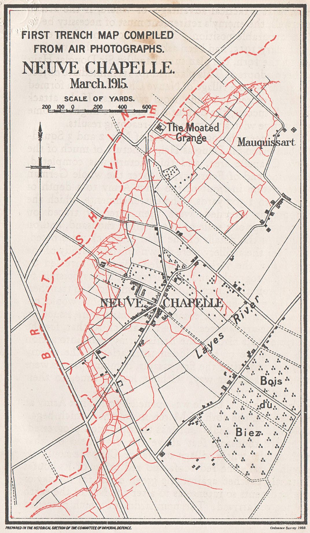
/https://tf-cmsv2-smithsonianmag-media.s3.amazonaws.com/filer/22/c7/22c71530-bd66-4665-b4b8-3496b2d7378d/neuvechapelle_detail.jpg)
When the battle was over, more than 20,000 soldiers were dead, injured, missing or taken prisoner from the battlefield, and the village of Neuve-Chapelle was just a name on a map. Wednesday March 10, 1915 dawned with a light snowfall that soon thickened into damp fog; nonetheless, British aircraft took to the air to fly over enemy positions, bombing railway lines and advancing reinforcements while the artillery aimed their guns at the German targets. At 7:30 a.m. the British launched the biggest artillery attack in history, pulverizing the German trenches. In his diary, British officer Herbert Stewart wrote: “The earth shook and the air was filled with the thunderous roar of the exploding shells. To the watching thousands the sight was a terrible one; amidst the clouds of smoke and dust they could see human bodies with earth and rock, portions of houses, and fragments of trench hurtling through the air.” In just 35 minutes, the artillery fired off more ammunition than that used by 500,000 British soldiers over the whole three-year duration of the Boer War 15 years earlier.
Prior to the battle, the Royal Flying Corps—the air arm of the British Army—had defied the weather to take a vast number of aerial photographs of the German positions. “My table is covered with photographs taken from aeroplanes. We have just started this method of reconnaissance, which will I think develop into something very important,” wrote Brigadier General John Charteris a few days before the attack.
Strategic aerial photography began rather incidentally—the first images were taken by pilots who photographed cities, landmarks and beautiful landscapes using their personal cameras to have something to show to their family and loved ones. But despite this, nobody had thought of using systematic aerial photography in map-making—when French captain Georges Bellenger established a dedicated aerial photography division and presented his superior with images he believed could be used to create maps, his superior informed him that he “already had a map.”
Neuve-Chapelle is situated in the French lowlands, close to the Belgian border. The town is neither large nor important, but as fate would have it Neuve-Chapelle became part of the northern Western Front, and therefore a strategic target. If Allied forces could pass through the town and make it to the larger city of Lille, they would also be able to intercept the railway lines, roads and canals used as transport routes by the Germans.
British planes photographed the town and surrounding countryside in detail prior to the planned attack—the obtained images formed the basis for a map that was printed in 1,500 copies and distributed to the troops who would go into battle. The information was invaluable—the Allied forces could now study the battlefield and analyze where a German counter-attack was most likely to occur. For the first time in British military history, the army was able to stage an attack with a full overview of the enemy’s defense lines, positions and hideouts. From this point onwards, maps based on aerial photographs became an integrated part of the Allied strategy.
Excerpted from Theater of the World: The Maps that Made History, copyright 2018 by Thomas Reinertsen Berg. Used with permission of Little, Brown and Company, New York. All rights reserved.