Private Pilots, NASA Wants Your Help
The space agency is looking for general aviation pilots to help track harmful algal blooms.
/https://tf-cmsv2-smithsonianmag-media.s3.amazonaws.com/filer/7f/0c/7f0c0236-bfea-4529-bc17-dd091b05f86f/rafat_ansari_right.jpg)
Ever wanted to fly for NASA, but lack test pilot experience? That’s ok! If you own a general aviation airplane and don’t mind flying over water, NASA wants to speak with you. The agency, along with its research partners in the National Oceanic and Atmospheric Administration and universities, are looking for a way to track harmful algal blooms. You can fly whenever and wherever you like, so long as it’s over water. The only catch: It’s all on your personal dime.
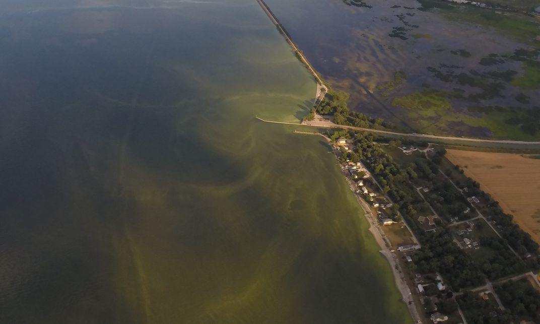
Algae is a catchall term for a variety of microscopic, photosynthetic plants and bacteria that float on or near the surface of the water, using chlorophyll to absorb energy from the sun. In the right conditions (warm, still water) they reproduce exponentially, forming what usually looks like a green or reddish floating blob—think pond scum—called an algal bloom. These blooms are natural, and small ones can be found nearly any place with relatively still water; they produce oxygen like other plants, and can make great meals for a wide variety of sea life.
Algal blooms thrive on nutrients like phosphates, one of the primary ingredients in fertilizers that are spread on farms by the ton. The runoff from farms makes its way into local waterways, eventually concentrating into drainage basins, causing blooms far larger and more frequent than would occur naturally. Algal blooms are generally harmless in natural quantities, but big, sustained blooms cause big problems. All those algae dying and decomposing (they have very short lives) brings bacteria that consume oxygen, leading to hypoxic ‘dead zones’ where virtually no life can survive. Blue-green algae also produce a waste substance called microcystin, which is toxic to people and animals.
Forecasting exactly when, where and how these Harmful Algal Blooms (HABs) will begin and grow is still a problem. That’s where general aviation comes in.
“We know a great deal about the dynamics of HABs—how they respond to changes in nutrient concentrations, waves, sunlight, temperature, etc,” says Rafat Ansari, a scientist at the NASA Glenn Research Center in Cleveland and principal investigator of this citizen-science project. “But there is much that we do not yet know about how these factors interact to produce an HAB or the HAB life cycle. Nor do we understand in a bloom of Microcystis, the most serious HAB species for fresh-water ecosystems, the conditions that lead to a bloom becoming toxic.”
Finding and tracking HABs is mostly done via satellites, which deliver impressive images but have their downsides. Their images are infrequent, and the data takes a long time to deliver and analyze. The satellites can’t see through clouds, can’t move around to track the blooms, and of course are very expensive.
General aviation airplanes, on the other hand, can fly low, underneath many of the clouds that block a satellite’s view, and they’re far more flexible. So NASA and others have enlisted volunteer pilots to overfly waterways with cameras mounted to the wings, automatically taking geolocated pictures. Many private pilots look for excuses to fly (popping over to another airport for lunch is commonly called a “$100 hamburger” flight), so why not gather some useful data while they’re up there?
“There are about 600,000 private pilots in the U.S. and over 200,000 GA aircraft,” says Ansari. “A fraction of this untapped resource can be used to study scientific issues in the nation’s waterways….GA pilots are more knowledgeable of the communities they live in, and are therefore aware of the water-quality issues near them. As citizens, they love to help their communities.”
It’s all done on a purely volunteer basis: NASA pays for neither fuel, nor time, nor the camera, but they also don’t ask much in return. The agency prefers pilots who routinely repeat the same flight paths, at altitudes between 2,000 and 3,000 feet, and at times of day when there isn’t much sun glare. But for practical purposes, pilots are free to choose their own timing, flight paths, and cameras. That’s not ideal for scientists, who usually need standardized data in order to compare results, but for basic HAB-tracking and -forecasting it’s good enough.
“My desire and dream is to have a network of pilots around the country, covering affected waterways from coast to coast and lakes and reservoirs,” says Ansari. But he may have to wait a while. Around 100 pilots responded to the first round of requests, but Ansari says the team doesn’t have the resources to download that much high-quality data in a systematic way. Currently only six pilots are making regular HAB-reconnaissance flights over Lake Erie (in 2014 a HAB temporarily shut down Toledo, Ohio’s water supply) the Mississippi River, and California coastline.
So if your next $100 hamburger is somewhere across the lake or down the river, you can get more information and sign up on the project’s website.