Surveyor 1, America’s First Lunar Landing
A past milestone…and possibly a future one
/https://tf-cmsv2-smithsonianmag-media.s3.amazonaws.com/accounts/headshot/blog_headshot_spudis-300x300.jpg)
/https://tf-cmsv2-smithsonianmag-media.s3.amazonaws.com/filer/49/c7/49c7b633-7d1f-4de3-ae50-26cbd1abe643/surveyor_i-20.jpg)
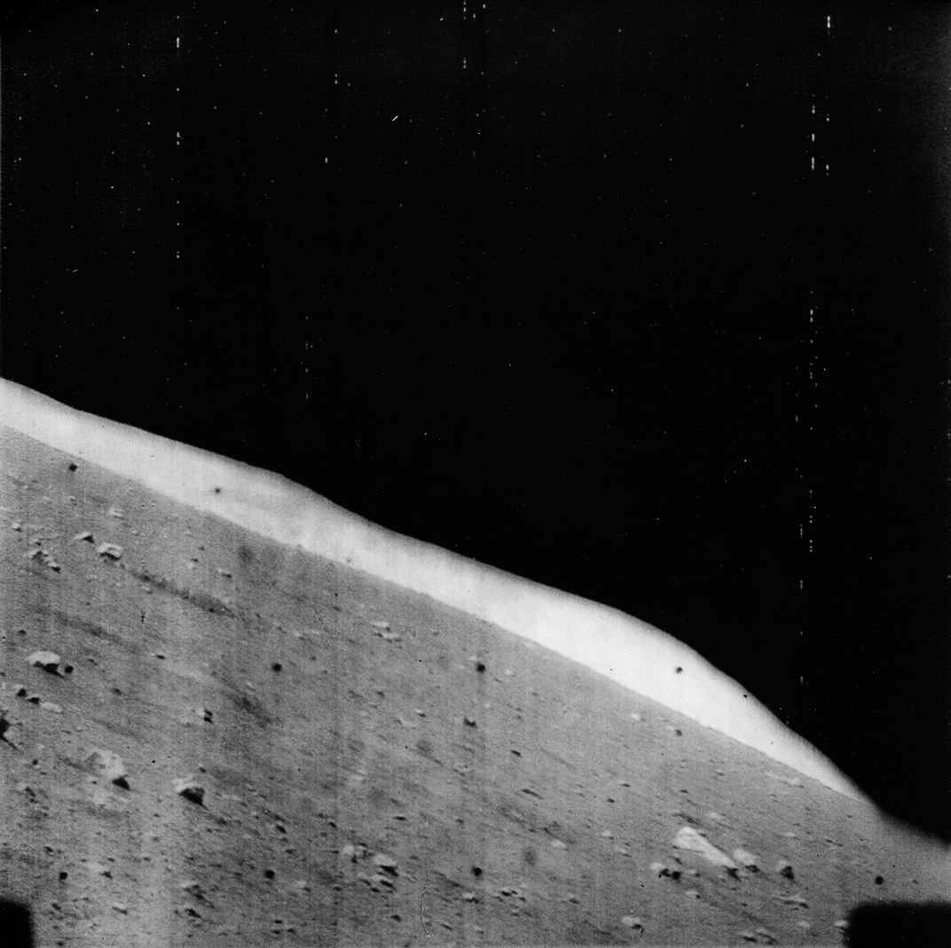
Today marks the 50th anniversary of the lunar landing of Surveyor 1 in a “ghost crater” in the Oceanus Procellarum, the mare plains of Flamsteed P. This mission will always be remembered as a key event in the frenzied history of the early Space Race—America’s first attempt to soft-land a spacecraft on the Moon. Although the Soviet Luna 9 mission had soft-landed on the lunar surface three months earlier (after a few failed attempts), with Surveyor 1 the Americans pulled off a soft landing on their first attempt, and with it got a much needed boost in confidence at a critical time in the Soviet-American race to the Moon. This exciting story is well told in a monograph by my good friend, Bill Mellberg, whose father Frank helped design the Surveyor TV camera.
The series of robotic spacecraft conceived as precursors to the Apollo human landings had specific goals designed to pave the way for people. The Ranger missions were the first and simplest—spacecraft equipped with cameras designed to crash land on the Moon, taking a series of ever more detailed pictures on the way down. The Ranger program had a rocky start when its first six efforts all failed for one reason or another. The failure of Ranger 6 to return any data was particularly maddening after it was discovered that a preventable electrical short during the launch had damaged the TV system. But with the successful flight of Ranger 7 in July of 1964, the jinx was broken and a series of detailed pictures of the Moon (showing craters of ever increasing number with ever decreasing size) were sent back to Earth. The images from the last three Ranger missions documented the process of the creation of regolith—the fragmental layer of debris (broken rock and soil) that overlies bedrock on the Moon.
The Surveyor program was initially designed as a combination orbiter and soft lander. The orbiter was to take survey images of the surface to find possible future human landing sites and verify that they were safe for such landings. However, the vidicon tube technology of the 1960s meant that orbital images would not have resolution sufficient to document all the hazardous rocks and craters that might be present. Thus, it was decided to discontinue the orbiter portion of Surveyor and have it concentrate solely on the soft-lander. In addition, five Lunar Orbiter missions based on the Pentagon’s Discoverer series of spy satellites and run from NASA’s Langley Research Center (not from JPL as were other robotic missions) took images to document the Apollo sites from orbit using a film-based system, which developed the fine-grained film onboard the spacecraft, then scanned it and radioed the data back to Earth.
Focusing solely on a soft lander was a blessing, because achieving that task was sufficiently formidable as to require all available JPL talent—which was considerable. Surveyor turned out to be a robust and successful design; five (of a total seven) missions successfully landed on the Moon and returned abundant data on the nature of the regolith. Television images from the Surveyor landers showed the rocky, dusty surface of the Moon, assuring designers that the regolith could support the heavy mass of landers and that the surface was not so rough as to create any undue hazard for the Apollo missions to follow. In this sense, they served their purpose of documenting the physical conditions of the lunar surface for Apollo.
But the Surveyor missions were also a boon to lunar science. The images from the Surveyor landers allowed us to count craters down to millimeters in diameter, confirming our inferences that craters on the Moon form a continuum of astonishing range, from thousands of kilometers to tens of microns in diameter. For the first time we saw rocks on the Moon in amazing detail, including breccias with bewildering complexity. Craters with abundant rocks on their rims must have dug down deeply enough to excavate bedrock; by measuring the diameters of craters with rocky rims, we could estimate the thickness of the regolith. We estimated the grain size of the regolith from its adhesive properties and studied its bearing strength and density. Finally, Surveyor carried instruments that allowed us to make the first chemical analyses of the Moon’s surface materials. We found from these experiments that the dark maria of the Moon are rich in iron and titanium, while the one Surveyor lander sent to the lunar highlands (near the crater Tycho) is rich in calcium and aluminum. These data reflected the basic dichotomy of the Moon’s crust of mafic, iron-rich maria (lava) and light-toned, aluminum-rich highlands (a division later confirmed by the samples returned by the Apollo manned missions).
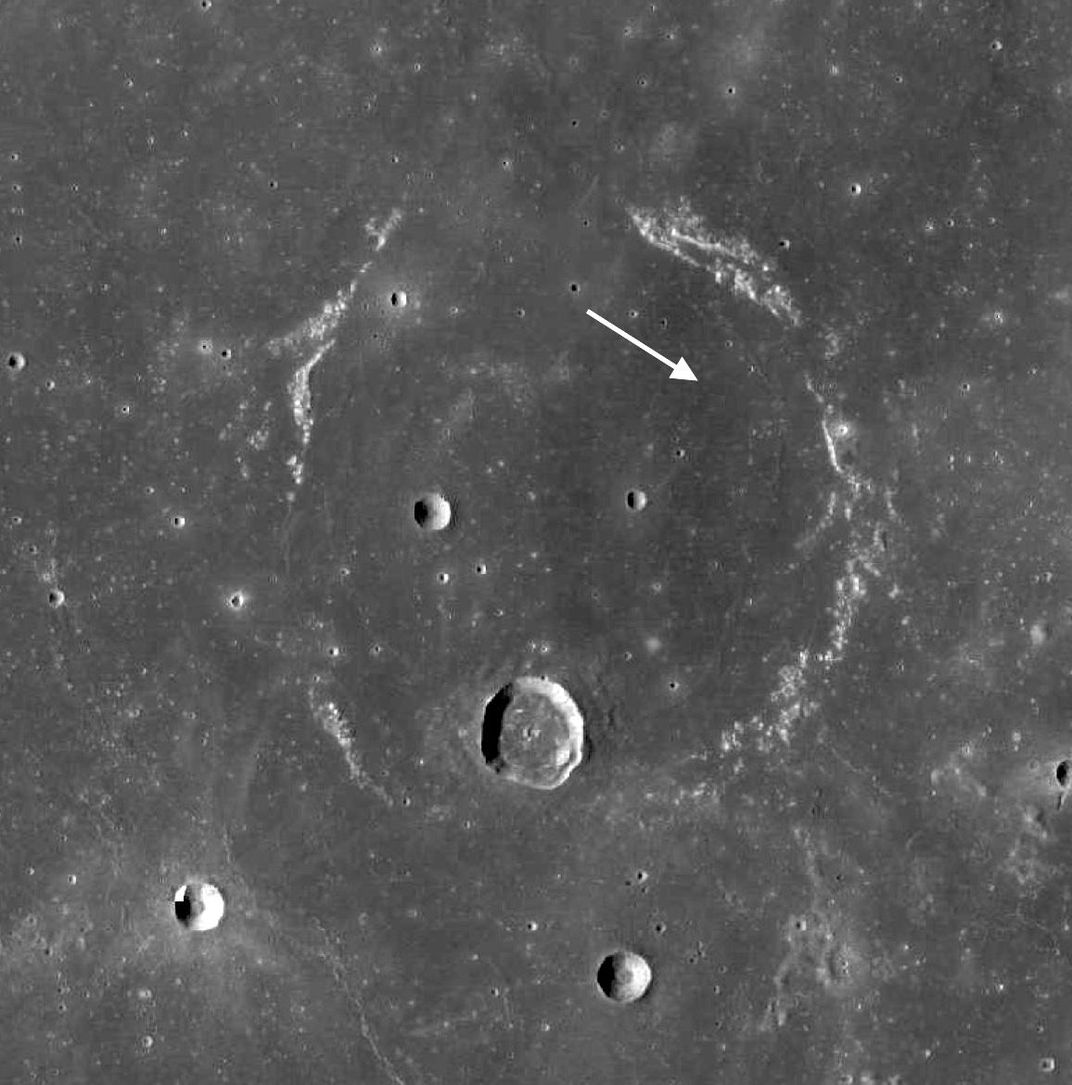
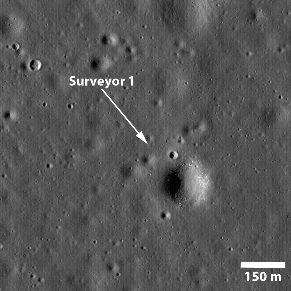
The Surveyor 1 mission, whose golden anniversary we celebrate today, is particularly significant in a special way. Measurement of regolith thickness from the diameters of blocky rim craters (mentioned above) shows that the regolith at the Surveyor 1 site is particularly thin, on the order of only about 1 to 2 meters. In contrast, the regolith at the Surveyor 5 site (which was near the future Apollo 11 landing site) is 5 to 8 meters thick. Why is there a difference?
It turns out that regolith thickness is directly proportional to the age of a given unit on the Moon. Because regolith forms from micrometeorite impacts, the older the unit, the more impacts it has undergone and thus, the thicker the ground-up bedrock (regolith) becomes. The conclusion is inescapable—the mare lava at the Surveyor 1 landing site is much younger than the lavas of the Apollo 11 site, dated from returned samples as about 3.6 billion years old. In fact, the regolith of the Surveyor 1 site is thinner than any other mare site on the Moon that has been measured. Work done by Peter Schultz and myself over 30 years ago estimated the age of the mare lavas of the Flamsteed P region to be less than 1 billion years old (very old by terrestrial standards, but young by lunar reckoning), making the Surveyor 1 site one of the youngest lava flows on the Moon.
Here is a legacy for both Surveyor and Apollo—we want to know when volcanism on the Moon stopped (to date the duration of volcanic activity on the Moon and to pin down its thermal timeline). To do so requires identifying the youngest lavas on the Moon and obtaining samples of that flow for radiometric dating. Such dating might require the return of a sample from the lunar surface but it may also be possible to date rocks on the Moon in situ. We now know that the Surveyor 1 landing site will provide key data that addresses a critical area of lunar scientific knowledge. No one could foresee 50 years ago when Flamsteed P was selected as the Surveyor 1 site, just how significant that site selection and the mission would be (and will be) for lunar science and the space program.
/https://tf-cmsv2-smithsonianmag-media.s3.amazonaws.com/accounts/headshot/blog_headshot_spudis-300x300.jpg)