Alaska’s Crash Epidemic
How technology and an FAA regional office ended it.
/https://tf-cmsv2-smithsonianmag-media.s3.amazonaws.com/filer/Alaska-Crash-Epidemic-631.jpg)
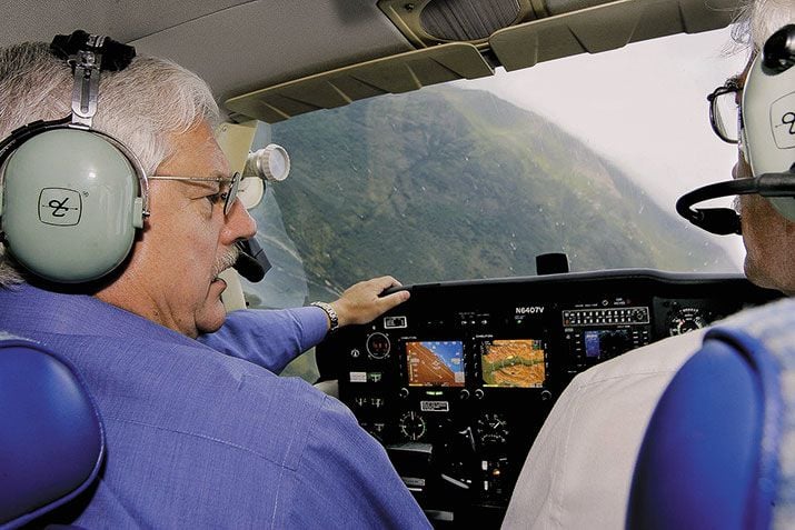
The slopes of Alaska’s Gastineau Channel framed the single-engine Cessna 172RG Cutlass on descent into Juneau on the clear afternoon of May 30, 1998. The airport had no radar and the mountains on either side blocked signals from other locations, forcing the pilot, Federal Aviation Administration official Dan Trusdale, to rely on what he could see.
If Trusdale saw the air tour helicopter, it was too late. The two aircraft collided. The helicopter landed with one injured passenger, but Trusdale and his passenger were killed. The documents they had planned to present later that day to Alaskan pilots and airline owners were scattered on the channel waters, papers that described a navigational system they hoped would cut the number of aviation deaths in Alaska.
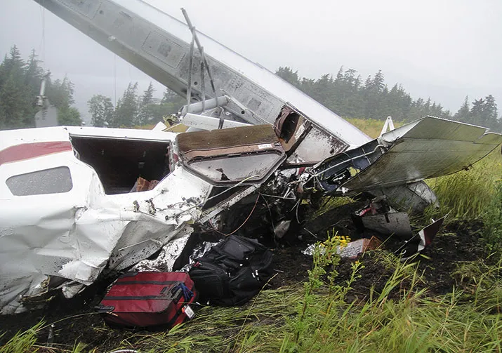
“The accident was a classic example of what we were trying to fix,” says Dave Palmer, who at the time was the National Airspace System implementation program manager for Alaska. In the 1990s, airplanes in the state were crashing every other day, with one death every nine days. The FAA had tried education, certification and safety programs, even a zero-tolerance policy that grounded pilots for 15 days if they were caught violating a safety regulation. “None of that worked,” says John Hallinan, an FAA flight standards officer at the regional office in Anchorage. What ultimately did work was the availability of federal dollars. The money enabled the Anchorage team to develop a technology-based program called Capstone.
In the mid-1990s, two reports—one by the National Transportation Safety Board (NTSB), the other from an FAA advisory commission, the Radio Technical Commission for Aeronautics (RTCA)—pointed to GPS and other technologies as part of the answer to Alaska’s aviation problem. Vice President Al Gore, working with George Donohue, the FAA associate administrator of research and acquisition, launched an initiative to improve air safety in Alaska and Hawaii, another state where aviation accidents were common. The initiative failed, largely for cost reasons, “but it showed us that the FAA might make some money available” for technology development, says Hallinan. He and his colleagues just needed a way to get at it.
Working in a fourth floor conference room of the moderately high-rise FAA building in downtown Anchorage, Hallinan and his team filled the dry erase boards on the walls with ideas that they then boiled down to a four-page document. From that emerged Capstone. The name was picked because the program pulled together ideas that safety advocates had discussed earlier but which had not been implemented—weather reporting, GPS-instrumented landing, and communications—“like a capstone that stabilizes everything underneath it,” Hallinan explains.
In the years leading up to the program, some Alaskan pilots used GPS units, placed atop glare shields or suction-cupped to windscreens. But these were neither FAA-certified nor accurate enough for pilots to fly under Instrument Flight Rules (IFR), the regulations and procedures for flying an aircraft using only the instrument panel for navigation. (Visual Flight Rules, or VFR, are those under which a pilot flies in weather clear enough to see the ground to navigate.) And while the GPS units helped in navigation and providing aircraft location, they did not survey the airspace to find other aircraft in the vicinity, enable communication with another pilot nearby, or provide a data link to air traffic controllers. And most Alaskan pilots didn’t use GPS anyway, instead relying on radios, magnetic compasses, and wristwatches. Dead reckoning and a bag full of maps got them from one place to another. Or not.
In Alaska, more than 39 mountain ranges with towering peaks and deep gorges can ensnare aviators in sometimes fierce and rapidly changing weather. When the terrain gets snowed over and ceilings drop, “it’s like trying to fly inside a bottle of milk,” says Elmer Webster, a 30-year veteran of the Alaskan skies. “Mix strong gusty conditions with freezing rain or snow and air traffic congestion, and you have a recipe for death by airplane.”
Using the findings in the NTSB and RTCA reports, Hallinan and several FAA colleagues decided three things would make Alaskan skies safer: determining aircraft location, identifying aircraft in airspace to avoid mid-air collisions, and preventing “controlled flight into terrain”—fully functioning aircraft crashing into the ground or sides of mountains.
The key, they determined, would be to develop a system that provided pilots in Alaska with GPS-based surveillance, weather data, and enhanced flight communications.
***
Although accidents were rampant throughout the state, Capstone put those technologies only in commuter and charter aircraft, and just those aircraft that flew in areas where crashes were prevalent. An early focal point was Bethel, the commercial hub for Alaska’s sprawling Yukon-Kuskokwim Delta. Its airport is situated at sea level, and the area 35 miles around the facility is “flat as a fritter,” says Webster. “If you’re going to develop a system, the first place to do it is not in the rocks.”
Several mountain ranges separate the FAA’s radar in Anchorage and the coastal plain where Bethel is situated, blocking signals from aircraft below 5,000 feet. Supplies flown into Bethel are air taxied to 53 villages in the delta, some just a few miles apart. For many, aviation remains the only means of transportation. A Cessna 210 with four passengers and 300 pounds of mail might fly from, say, Bethel to Hopper Bay to Scammon Bay, then to Chevak, before returning.
Alaskans fly as often as people in the Lower 48 drive. Air taxis—single-engine aircraft with unpressurized cabins—take passengers to work and school, high school teams to games, food and medicine to remote villages. “Our options are a plane, several hours cross-country on a snow machine, or a day or two by dog sled,” says Webster. Single-engine Cessna 207s and 208 Caravans and twin-engine CASA 212s and DHC-6 Twin Otters are the workhorses, carrying passengers and cargo to small communities. “If someone orders a pizza from Bethel and they live in Napaskiak, it might be delivered by a Cessna 172,” says Webster.
Although busy by Alaskan standards, Bethel traffic could not justify the cost of its own radar. Neither could most airports in the state; according to the FAA, only 76 of 405—fewer than one in five—have paved runways.
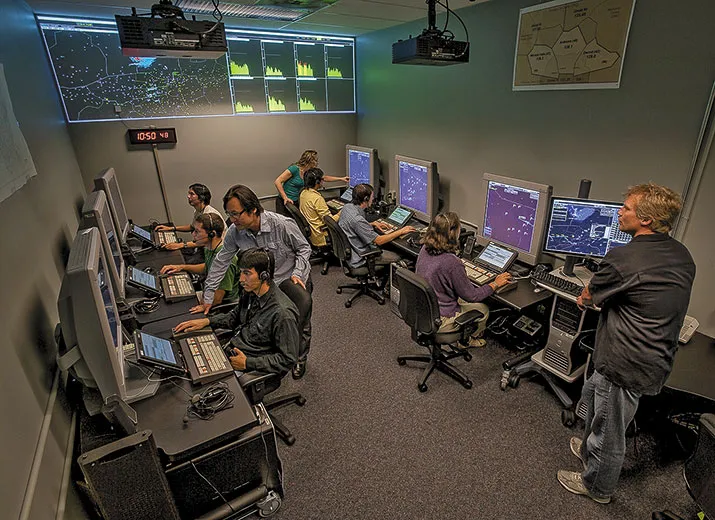
In the first phase of Capstone, funded by the FAA and focused on situational awareness, 208 airplanes were equipped with GPS and Automatic Dependent Surveillance-Broadcast (ADS-B) data links (see “How Satellites Make Flying Safer,” p. 63). Across the delta, 11 ground stations were installed to relay GPS data from aircraft to air traffic controllers.
With Capstone, air traffic controllers in Alaska could pinpoint ADS-B–equipped airplanes with better-than-radar precision, guiding aircraft along their routes. Information about winds aloft, temperatures, barometric pressures, and ceiling heights was sent to pilots in the context of weather maps.
Weather information was a big deal. A 1995 NTSB report on Alaskan aviation recognized poor weather—and pilot acceptance of its risks—as the chief cause of the high accident rate. Those who flew when they shouldn’t were called “scud runners.” Gary Childers, an FAA flight standards official who flew for the military and has thousands of hours flying over frozen tundra, admits to being a scud runner. Once, in an Army helicopter, Childers was flying in whiteout conditions under a 500-foot cloud ceiling with one-mile visibility, following what he thought was one river only to find out it was another. “I was fortunate to realize it and turn around,” he says, “but you get into those canyons and into situations where you can’t turn around. That’s probably how some of my friends were killed.”
***
A New era for Alaskan aviation began on January 1, 2001, with veteran pilot Robert “Skip” Nelson at the controls of a twin-engine turboprop freighter, a CASA C-212 Aviocar, flying out of Anchorage. On any other day, 125 miles east of Bethel, Nelson would have been told by the Anchorage controller that he was about to fly beyond radar coverage, and would have been asked to take a fix on his destination. This fix indicates the position of the aircraft relative to its destination, as determined by radio beacons, compasses, or paper maps. More often than not, however, to bush pilots in Alaska, it meant flying under IFRR, an acronym, says Webster, for “I Follow Rivers and Roads.”
“But on that particular day, [the controller] said ‘Radar services terminated, your ADS-B vector is…,’ ” recalls Nelson who, at that moment, became the first pilot to use an FAA-certified ADS-B system.
After Bethel, Capstone officials turned their attention to southeastern Alaska, a region that borders British Columbia and spans 600 miles from Ketchikan to Cordova, marked by glacier-cut fjords, steep mountains, and dense rainforests. More advanced technology was developed to handle the rugged terrain. Installed on about 180 airplanes, the equipment reported positions not only to controllers but to other aircraft as well, projecting the data on 3D displays of terrain and the surrounding airspace. Mountains had height; canyons, depth. Approaching aircraft appeared higher or lower, with vectors indicating direction and speed.
“We were beginning to fly like controllers control,” says Nelson. “The question controllers ask is ‘Do the chopsticks [flight paths] cross some place out there in space?’ and we were starting to do that from the cockpit.”
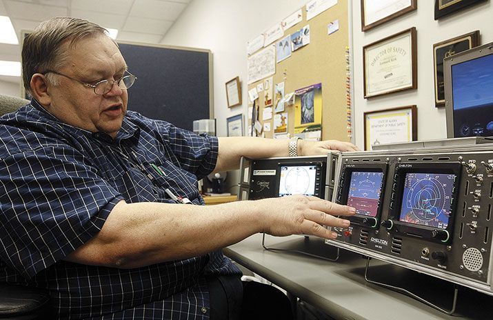
As the program matured, the technology became more sophisticated. A new legion of navigation satellites helped correct errors in GPS data, pinpointing locations to within meters. Cockpit displays consisted of two LED screens. One was the Primary Flight Display, with airspeed, altitude, and heading imposed on a forward-looking 3D view of the terrain. The “highway in the sky” feature kept pilots on course by guiding them to fly inside a series of on-screen boxes. The other display typically showed a top-down view of the terrain, airspeed, ground speed, and heading. If needed, however, it could be reconfigured at the touch of a button as the backup Primary Flight Display.
Within a few years of its first use, pilots were making fewer errors. Routes were more direct. Airplanes needed less separation, making air travel more efficient. Seeing the positions of other aircraft on their cockpit displays, pilots sequenced their landing approaches like cars entering a highway from an on-ramp. Following their aircraft on office computer screens, airline operators could better plan for the arrival of passengers and cargo. Aviation accidents in Alaska dropped by almost half.
In the first two phases of Capstone, the FAA had purchased the required avionics and installed them on small commercial airplanes. But in Alaska, many more private aircraft had crashed than commercial ones. When the second phase of the program ended, a loan program from the state government encouraged owners who had not received the instruments to buy their own, but few did. A big reason was the cost: Between $20,000 and $30,000 for a single airplane.
Even when the equipment was free, it was a hard sell, especially in the beginning. Many pilots feared that FAA officials would use what they learned to charge aviators with violations. While pilots had reservations, many airline operators were enthusiastic, for the same reason that gave some pilots pause: ADS-B provided operators a way to track their airplanes.
It was common among Alaskan bush pilots to take on side jobs, which they would do on company time. Others flew where they weren’t supposed to. Webster recalls one owner who, while viewing an ADS-B demonstration early in the Capstone program, pulled out his cell phone and called the dispatcher, inquiring about the location of a certain pilot, who was supposed to be hauling cargo. “The dispatcher told him the pilot was flying, and the owner fired back, ‘No he’s not. He’s over at his mom’s. I can see him on the screen. You tell him to get back on route.’ ”
***
The promise of more revenue for airplane operators rallied support for Capstone. But it was safety that won over the pilots. Hallinan says that pilots eventually supported Capstone for one reason: “Everybody here in Alaska knows somebody who has died in a plane accident.”
One was Dan Trusdale, who balanced work on Capstone with his regular FAA assignment: inspecting and assessing equipment and facilities at Alaskan airports. Trusdale died at a time in the Capstone program when ADS-B was in its infancy and hadn’t yet been proven to work. The loss of Trusdale “put the statistics in italics for everyone back east,” says Webster. New FAA Administrator Jane Garvey went to Trusdale’s funeral and returned periodically to Alaska, attending meetings with the state’s aviation community. These were arranged by the Capstone Industry Council, which the FAA started as part of an outreach program to the Alaskan aviation community. By 1999, the council had won the support of Alaskan aviators and airline operators. A letter from Garvey committed the federal government to Capstone.
But a critical step remained: a demonstration that proved ADS-B would actually work under real conditions. The FAA had to sign off on the test, a process hampered by red tape strung by mid-level bureaucrats. The solution came amid severe weather, not in Alaska but in the nation’s capital.
On September 19, 2000, Washington, D.C., braced for Hurricane Gordon, and non-essential federal workers were told to stay home. It was just what Hallinan needed. “Most of the [FAA] building was gone and I was able to have meaningful conversations with decision-makers without having a lot of front guard to body-block me,” he says. Those discussions ultimately cleared the way for the FAA to approve Skip Nelson’s history-making test flight of ADS-B in January 2001.
In the years that followed, Capstone added the Wide Area Augmentation System (WAAS) to correct errors in GPS signals introduced by disturbances in the ionosphere and timing errors caused by variations in the orbits of satellites. With WAAS, position updates appeared on the flat-panel displays in cockpits and on controllers’ screens with up to five times the accuracy previously possible. Vertical precision was good enough to set up IFR approaches for landing at airports without controllers or radar-supplied glideslopes. And, if the ground-based transceivers failed for any reason, instruments onboard aircraft were receiving ADS-B data from each other, allowing pilots to maintain a safe distance.
***
Capstone reshaped a culture, just as its technology is about to change air traffic control in and outside of Alaska. When funding for Capstone ended in 2005 with less than two-thirds of the state covered by ADS-B, the FAA turned the effort into a national program with the Surveillance Broadcast Services Office, part of the George W. Bush administration’s NextGen program. The ultimate goal of NextGen is to use ADS-B as a replacement for radar. Hundreds of ground-based transceivers have already been installed across the United States, providing ADS-B coverage on the east, west, and Gulf coasts, as well as along much of the border with Canada.
By 2020, an advanced version of Capstone’s ADS-B will be the backbone of national airspace management in the United States. When the program is fully operational, all airplanes flying in the country will be required to have ADS-B avionics, which will provide what the FAA expects will be unprecedented traffic awareness and up-to-date weather information. If NextGen performs as well as Capstone, air travel in the United States should become more efficient, with more direct routes and shorter separations between aircraft during flight. The result is improved safety and efficiencies that the FAA expects will translate into hundreds of millions of dollars in annual savings.
The FAA was “looking for a solution for the future,” says Robert Lewis, the current Anchorage-based FAA regional administrator. “When they learned how successful our efforts were up here, they began to see that this might be the answer they were looking for.” Ironically, Alaskan pilots will not benefit from NextGen’s version of ADS-B, if they fly the many passes and canyons where ground stations have not—or cannot—be installed. The mountains still cut the line-of-sight communications between ground transmitters and aircraft, just as the horizon will terminate ADS-B transmissions to transoceanic pilots.
A space-based version of ADS-B, developed by Skip Nelson’s new company, ADS-B Technologies, overcomes the problem by using Globalstar satellites to relay signals between aircraft and ground stations. Over some of the harshest terrain in Alaska, pilots are testing this version of ADS-B for Nelson’s company, and I’m invited along for one of the tests.
For the first test of the year, Nelson is at the controls, and I am in the copilot seat. Our twin-engine Piper Navajo Chieftain lifts off from Anchorage’s Merrill Field, flies down Cook Inlet, then banks toward the mountains. Over the next hour and a half, we fly between 300 and 500 feet above the ice pack and open water, below the line of sight of ground-based ADS-B transmitters.
Blinking green lights on the ADS-B Link Augmentation System (ALAS), mounted on a table behind my seat, verify that a Globalstar in low Earth orbit is relaying our ADS-B signal to ground stations, and that we are receiving signals from those stations as well. The signals complete this circuit within 400 milliseconds, with the electronics inside the ALAS box interpreting and sending them to the multifunction display in the Chieftain’s cockpit, which indicates our position within 50 feet of actual.
“That is weapons-grade accuracy and reliability,” the former Top Gun instructor tells me over the headset.
We are hugging the right side of a canyon, a position reflected on-screen by a twin-engine icon on the right side of a narrow band of green, sandwiched by bands of fire red. “You don’t want to fly down the middle,” Nelson says. “If you run into trouble, you want to be able to turn around.”
As if by tradition, Alaska is again the proving ground for a new kind of ADS-B. ALAS has followed our trip up through the Kenai Mountains, over the glassy heights of the Skilak Glacier, and across the Harding Ice Pack. Throughout, we have been in a “terrain shadow,” where neither radar nor terrestrial ADS-B could see us. The Navajo continued in this shadow, flying down the Ailik Glacier, with its eerie blue crevasses, then over the Kenai Fjords and Resurrection Bay, past Seward, and back to Anchorage, each step plotted on the ADS-B displays on the airplane’s instrument panel.
ALAS provided the data link that ground stations alone could not, but the information was the same as that from a standard ADS-B system: pinpoint location of the airplane, its altitude and heading, the 3D moving terrain, the texting, and weather maps. Before Capstone, none of that was available.
In 2007, the National Aeronautic Association presented the developers of ADS-B, Nelson included, with the Collier Trophy. Displayed in the National Air and Space Museum, the trophy is awarded each year for “the greatest achievement in aeronautics or astronautics in America, with respect to improving the performance, efficiency, and safety of air or space vehicles.” Nelson and I are now completing the test of an even better version of ADS-B.
As we near Merrill Field, the mountains recede, as does the bright red on the Chieftain’s 3D terrain map. We bank toward the airport, and through the windscreen, we see Runway 25. A few miles farther are downtown Anchorage and the FAA regional office, where the modern age of navigation began. Behind me, its lights blinking green, is one possible future.
Frequent contributor Greg Freiherr last wrote “Orbiter Autopsies” (Apr./May 2012), which reported on NASA’s examination of the shuttle fleet.
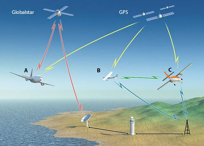
In the illustration above, aircraft A is flying beyond the range of a ground-based transceiver, but it continues to broadcast ADS-B data, which is received by a Globalstar satellite. The satellite transmits the airplane’s data to air traffic control via a ground antenna. Aircraft B and C are both within range of a GBT, which gives them traffic and flight information. B and C also receive each other’s air-to-air ADS-B data. Curtis Sayers