A Crater of Cosmic Proportions
To appreciate the majesty of Northern Quebec’s Pingualuit Crater, you’ve got to see it from an airplane
/https://tf-cmsv2-smithsonianmag-media.s3.amazonaws.com/filer/39/ba/39ba7673-f059-47ee-809a-fa4f195cbe74/17a_am2015_airplaneview2007_live.jpg)
A little more than a million years ago, a space rock wider than a football field struck northern Quebec, blasting a hole 2.14 miles wide into Earth’s crust. In the summer of 2008, I stood on that crater’s rim, gazing down into the crystal-clear lake inside and reflecting on the good fortune that had allowed me to fulfill this lifelong dream.
As a boy in Ontario in the 1950s, I had spent long hours staring through a telescope at the moon’s mysterious craters. One day I saw a TV documentary that said Earth had them too. In fact, there were craters in Canada, and one in nearby Quebec. I was spellbound. I vowed that someday I would see that crater for myself.
In the decades that followed, I joined the Canadian navy, had a family, pursued a career in electronic engineering, earned a pilot’s license, and bought a Cessna Cardinal C177B. After I retired, I returned to my boyhood avocation, systematically exploring many of North America’s impact craters from the air and on foot: the Barringer Crater in Arizona, Pilot Lake Crater in the Northwest Territories, Mistastin Crater in Labrador. But more thrilling than any of them were my visits to Pingualuit (the name the New Quebec Crater had been given in 1999), the subject of my promise to myself all those years ago. “Pingualuit” is an Inuit word meaning, roughly, “where the land rises.” The Inuit knew of the crater’s existence long before anyone else.
Researching the logistics of flying there from the south, I discovered my visit would entail considerable planning. My Cessna could remain airborne for only about six hours at a time, and in this region airports with refueling facilities are far apart. The distance to the crater from the only reliable source of fuel demanded exact calculations of fuel burn and payload. Only by carrying extra fuel on board would I be able to buy myself a luxurious window of observation time over the crater—at most 20 minutes—before I would have to fly to Salluit Airport on the northern tip of Quebec to refuel. A major weather change would force me to cancel the flight. In 2001, I attempted the trip.
Originating at Rockcliffe Airport in Ottawa, Ontario, my flight plan included long hops over the Canadian Shield—a large region of exposed Precambrian rock that encircles the Hudson Bay—with refueling stops at remote airports throughout Quebec. On the way, I passed over the Manicouagan Crater, one of Earth’s largest, and recognizable on maps and from the air by a large circular lake surrounding a mountain of impact-melted rock. (I would explore Manicouagan in 2006.) Arriving at Schefferville Airport in Quebec, I landed in a 90-degree crosswind—my Cardinal’s specified limit, and a reminder that the wind in this region can be treacherous, changing drastically and without warning.
The Eaton Canyon, north of Schefferville, is a must for any explorer in that vicinity. The flow of water through that rock-faulted slot is a hypnotic sight, and one that can be appreciated only from a small airplane. I then followed the Caniapiscau River north to Ungava Bay. By the time I reached Kuujjuaq Airport, a heavy cloud layer was descending, but I managed to land in Marginal Visual Flight Rules conditions. The next day was to be my hop to the crater. I checked the weather report and loaded extra fuel on board, just in case.
When I crossed the tree line north of Kuujjuaq, I was over a vegetation-free moonscape of canyons and plains. Beneath a 1,500-foot cloud layer, I caught my first sight of the Pingualuit Crater. From a distance it looked like a small hill slowly coming into focus on the horizon. The steepness of the crater rim hid the lake within from my vantage point at that low altitude. It only came into view when I crossed the rim. I marveled at the crater’s almost perfectly circular shape.
I had prepared most of my adult life for this moment but I was still struck by the crater’s immensity. It filled the aircraft window. Due to its circular shape, Pingualuit was initially suspected to be a kimberlite pipe—a carrot-shaped compartment in Earth’s crust formed by volcanic forces. Not until the late 1980s was it confirmed to be the product of an asteroid strike, when researchers found material that could only have been melted during an explosion caused by the impact of a cosmic rock.
I circled the crater a couple of times, taking photographs and video footage. Even from 1,000 feet the clarity of the water was impressive. It’s one of the clearest lakes on Earth, and, at 876 feet, the deepest in Quebec. I climbed for a wider view; even though it was August, I hit freezing temperatures. Flying by my instruments only, I slowly descended to warmer air so I could clear my fogged-in windows.
After my short allotted time over the crater I proceeded further north to Salluit Airport on the Hudson Strait coast, where I refueled from the containers I’d carried. This village is situated on a beautiful fjord just off the Hudson Strait. While flying north I buzzed an abandoned scientific station, noticing the wind damage to the facility. My return itinerary included a side trip to explore the Couture Impact Crater, southwest of Pingualuit.
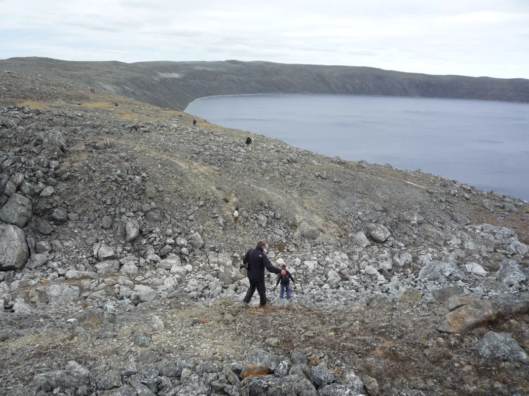
When an airport was constructed by Pingualuit Crater and the park was opened to visitors, I had an opportunity to explore the crater on foot. In 2008, I flew my airplane to Kuujjuaq to catch a Twin Otter flight to the crater. (Only chartered aircraft may land on the airport’s small strip.) I spent four wonderful days hiking around the crater, burrowing into an Arctic-grade sleeping bag each night. Circumnavigating the crater rim took a full day of walking, with constant maneuvering over large boulders.
I climbed down the steep inner slope and dipped my foot in the freezing crystal-clear water. I saw bedrock fractured in the same way I’d observed around the Manicouagan and Sudbury Craters. I marveled at an old Inuit campsite preserved as though it had been inhabited only recently. I sat still for an hour as a small herd of caribou walked past me.
I tried to imagine the crater’s creation: A giant rock entering Earth’s atmosphere at 27,000 mph, causing a blinding flash of light. Five billion tons of granite was vaporized in an instant. What remained was where I now sat, grateful to have fulfilled my boyhood dream.