I Flew the Same Route as the 1920s Airmail Pilots, and Lived to Tell the Tale
From Omaha to Salt Lake City, without GPS.
:focal(1019x460:1020x461)/https://tf-cmsv2-smithsonianmag-media.s3.amazonaws.com/filer/af/6a/af6a692f-8388-4777-98be-f009b79f776c/airmail_pilot.jpg)
I’m standing in Parking Lot 5 of the Scott Campus of the University of Nebraska Omaha. It’s a cold, gray evening, with low ceilings and spitting rain. I look around at the towering buildings on all sides, and it’s hard to imagine that this was once the site of an airfield. If I had been flying the Omaha-to-Cheyenne route back in the glory days of airmail, this would have been my starting point.
Now you need a permit to park your car here.
All that’s left to show that an airport once existed is a forlorn metal plaque erected by the Nebraska State Historical Society. It faces a busy street. In the morning I’ll use modern GPS to arrive in the air above this very spot, but after that, I’m going to attempt to re-fly a third of the transcontinental airmail route using nothing but a set of written instructions that are now nearly 100 years old.
Before aeronautical charts, before the concrete arrows and the flashing airway beacons, before radios, the U.S. Post Office Department was bootstrapping its fledgling airmail experiment into a full-blown, regularly scheduled, coast-to-coast venture, and it needed a means for new pilots to find their way. The solution? A contest among airmail pilots for the best-written description of each leg of the route. The collection was bound together into a slim volume called Pilots’ Directions.
Published by the post office in early 1921, Pilots’ Directions is a field guide to contact flying the transcontinental route, leapfrogging from landmark to landmark, staying “in contact” with the terrain. Being a multi-author work, it doesn’t read with a single voice, nor, having been written at a time when cross country flying was still in its infancy, does it give unified advice: Some pilot authors suggested using railroads as landmarks; others, the descriptions of towns. Others still give advice relying upon lakes and rivers.
Starting in New York, the route crossed the Alleghenies, slid under the Great Lakes, ventured out across the Great Plains, spanned the Wyoming Rockies and the mighty Wasatch Range guarding the Salt Lake Valley, and traversed the rugged landscape of the far West before finally vaulting the Sierra Nevada to end on the far side of the nation in San Francisco.
Flipping through the book’s faded pages, I wondered if Pilots’ Directions could still be used to navigate the 2,640-mile route in today’s world. As the 100th anniversary of the book closed in, I decided to abandon a century of aviation progress and find out.
All I needed was an airmail airplane.
/https://tf-cmsv2-smithsonianmag-media.s3.amazonaws.com/filer/0d/4f/0d4f7584-c996-4cc8-92ce-765b1b693ed1/11c_fm2020_nasm_archivalomaha1924_a2006-8_live.jpg)
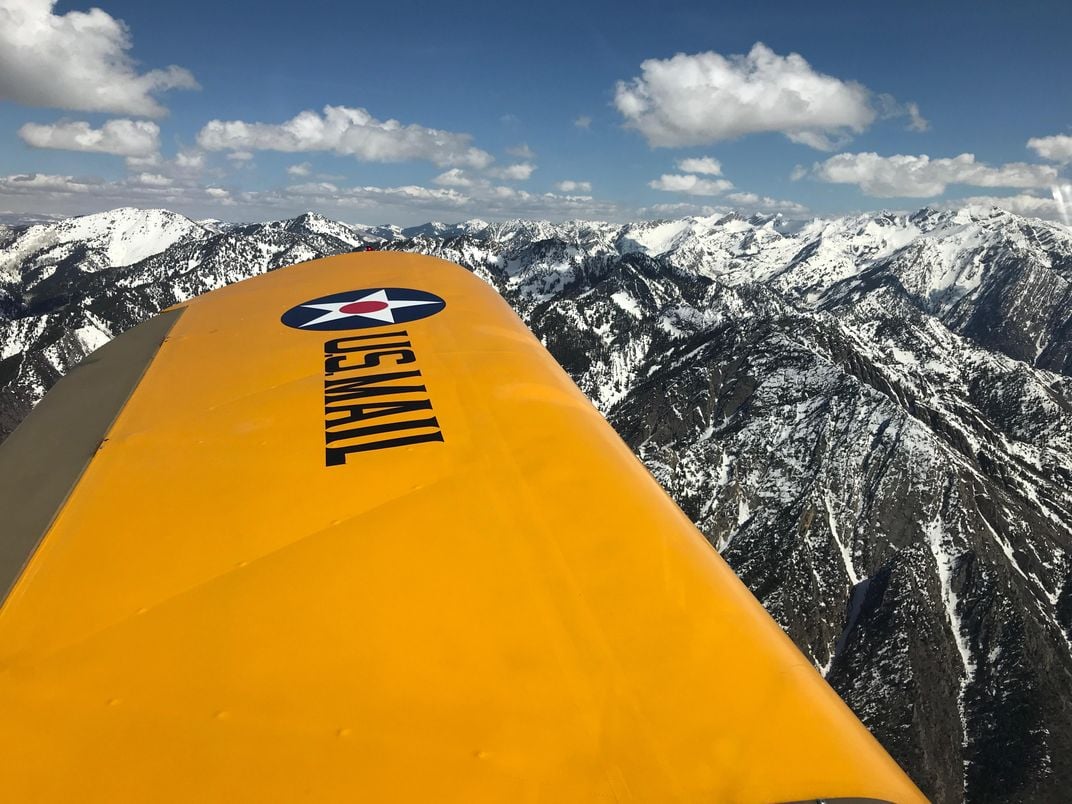
It’s a funny thing. People who own antique biplanes aren’t too keen about loaning them out to strangers. Truth be told, I didn’t waste time trying to snag the use of a Liberty-powered de Havilland DH-4, the sweetheart of the early mail, because the perfect airplane for the job was in the hangar next to mine: An Army brown 1946 Ercoupe with bright yellow wings, Warbler.
Now before you cry foul, consider the following: The ’Coupe has pretty much the same speed as the early mailplanes, and by sliding its doors down into its belly, I can transform it into an open-cockpit airplane. All it’s missing is an extra set of wings. Or maybe not.
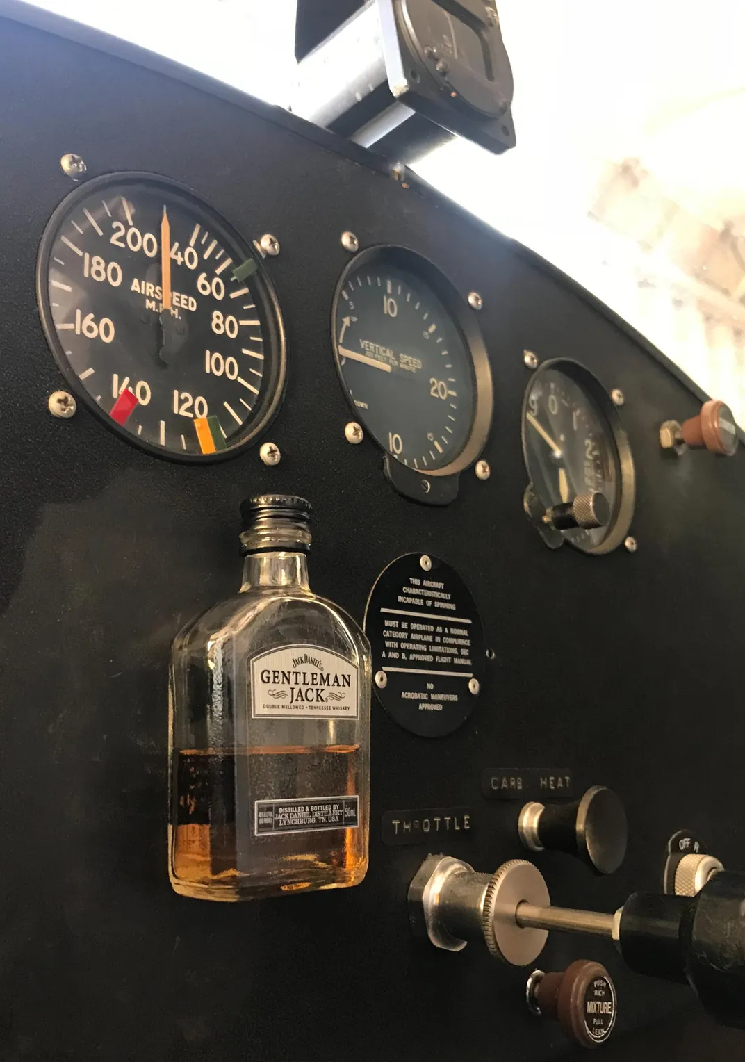
Thanks to the DH’s weak and collapse-prone landing gear, lower wing damage was a common occurrence, and even with warehouses chock full of war surplus parts, the “mechanicians” of the airmail service quickly ran out of lower wings. In his book Tracks Across the Sky: The Story of the Pioneers of the U.S. Air Mail, Page Shamburger observed that virtually every Postal Department DH-4 ended up flying solely on its top wings. Plus, this particular ’Coupe has exactly the same instruments the mailplanes had: rudimentary engine gauges, an airspeed indicator, an altimeter, a compass, and…well, that’s about it.
To get Warbler fully airmail worthy, I sent some pictures of early airmail airplanes to Victory Girl—a custom jacket-painting and airplane nose art business—who made me some special vinyl markings to dress Warbler for the part: bold text that simply reads, “U.S. MAIL.” To complete the transformation, I taped a half-empty bottle of bourbon to the instrument panel to serve as an attitude indicator—just like the airmail pilots did. Of course, it doesn’t work. The airmail pilots knew that too. But their ground-pounder bosses didn’t, and this was during Prohibition, after all.
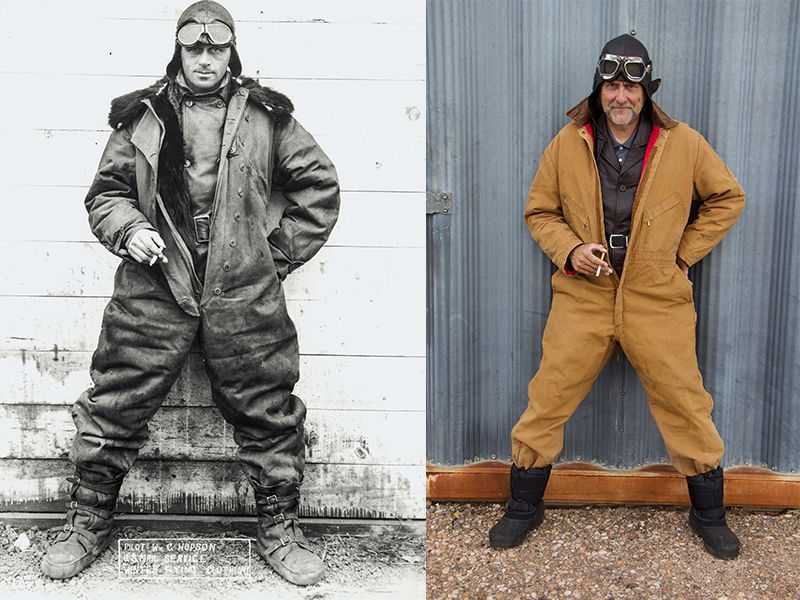
Now that Warbler looked the part, I felt that I needed to look the part too. I found a knee-length brown leather button-up jacket of the style World War I pilots wore. Then I dug out my longest winter scarf. It’s gray, not white, but it would do. Finally, I went online and bought a leather flying helmet. And goggles.
I was dressed for success. But would I succeed?
No one I knew was willing to bet on it.
Now I’m 1,000 feet up, attempting to channel my inner airmail pilot. Who will he be? Will he be the courageous “Wild Bill” Hopson, famous for his uncanny ability to find his way through any weather? Or will he be the hapless George Boyle, who was shown the door after getting lost on both of his first two airmail flights?
I twist my wrist to check the time on my Hamilton watch—09:27—then I jot the time down in pencil on a scrap of cardboard. The Hamilton company gave all the early airmail pilots free watches to help guide them along their routes. They didn’t give me one, but they were kind enough to lend me one for my flight, and I’m getting a big kick out of sharing this link with the past. I’m also coming to appreciate the importance of time in contact flying.
My loaner watch is saying I’m 20 minutes out from my simulated takeoff at the long-buried Omaha airmail field. I should be at Wahoo, which, according to Directions is a “fair-sized town three miles south of the course.” It adds, “Six railroads radiate from Wahoo.”
Ahead, and much closer than three miles from my course, is a town. But is it Wahoo? In the past 100 years, fair-sized towns have become cities, and new fair-sized towns have sprung up where none existed before. Every cluster of houses that passes under my wings triggers a flurry of confusion and doubt. Could that be Loup City? I shouldn’t be there for five more minutes. Has the wind let up? Or am I off course? Damn, there shouldn’t be a town here!
I divert south, coming in over the edge of town, anxious to find the six railroads, or at least evidence they once existed. I’m finding living railroads hard to spot in a landscape crisscrossed with roads and highways of every size, and dead railroads are even trickier. Most have vanished without a trace.
Peering over the wing, I see only two rail lines below. My heart sinks. Either I’m already Boyle-lost, or the world has changed so much in the last century that Pilots’ Directions is nothing more than a fascinating footnote in the dusty bin of aviation history. Then I see it: A 12-story water tower with 10-foot-tall letters spelling out WAHOO.
“Wha-hoo! It’s Wahoo!” I shout, pumping my fist in victory. Boyle is buried. Hopson swells in my breast.
Of course, this is cheating. Such convenient markers didn’t exist in the days of Pilots’ Directions. It was common practice for communities to paint their names on the roofs of their largest buildings, but that practice wasn’t formalized until 1926. Still, I rationalize using this modern intelligence by remembering tales I’ve read about lost airmail pilots landing in farmer’s fields to ask directions, which I’ve not had to do. Yet.
Then the ground begins to speak to me. Showing me clues to keep me on course. Rotted posts rising from the mud in a stream. A dead bridge’s tombstone. A smooth grass-covered grade through the hillocks, the ghost of the Chicago, Burlington & Quincy Railroad.
And right on schedule come David City…Osceola…St. Paul…all when and where they should be. Now that I’ve got the knack, contact flying is simple. Peaceful. Sailing along low to the ground, wind swirling through the open cockpit, I’m in touch with the aviators of old. Back when flying was physical, tactile, exciting.
Following Mason City, Pilots’ Directions informs me that, “no distinguishing landmarks are available” for the next 65 miles. It’s the most accurate description in the whole friggin’ book. I see only featureless prairie. Minutes tick by on my Hamilton. I fly west by compass, recalling Airmail Superintendent Benjamin B. Lipsner’s comment: “We had only a few instruments to contend with, and of these, the compass was the most troublesome.” My compass is better, but my directions were written by men using troublesome compasses.
Tick-tock. Tick-tock. I fly over the endless prairie. The sun is behind my left shoulder so I know I’m not radically off course, but at the same time my confidence in my archaic navigation skills is fading.
At the designated time, my destination of North Platte fails to appear.
Boyle is back.
My insecurities roar up larger than monsters. I start doubting myself again. I consider my options. I’ve arrived at all my other waypoints a hair ahead of schedule. Maybe the wind changed? Or did I drift north and bypass the city? I couldn’t have wandered south, as I’ve not crossed the Platte River—which is to the south of my course.
Tick-tock. Tick-tock. Nothing but prairie. So I’m either north…or I’m dead on course and I’ve hit headwinds. How long should I wait? And if I turn due south and fly until I hit the river, how will I know which way to turn to find the city and my much-needed refueling stop?
Tick-tock. Tick-tock. Damn you, Boyle.
Then, over a slight rise to the south, about seven miles away, are buildings. I bank left and point Warbler’s nose at the center of the rapidly growing signs of civilization. And there, on the east bank of the north branch of the Platte River, right where it has been for a hundred years, is the airport.
Hopson kicks Boyle’s butt out of the airplane.
Then, winging over the field, I’m instantly disappointed. I’d seen historic photos of the U.S. Airmail Station here: a classic art deco hangar with a graceful curved roof. In my mind’s eye, I believed it still existed out here in the middle of the Nebraska prairie, a time capsule. But once again, I find that nothing much remains of the airmail service’s past. The airport is grotesquely modern.
Still, I have mail to deliver. And like my wayfinding methods, my mail is old fashioned. Paper envelopes with stamps on them.
Of course, unlike the early airmail pilots, I find no ground crew awaiting me in a truck with the engine running, ready to pull the mail bags from my airplane the second my prop stops spinning. Instead, I find a mailbox in front of the terminal building, and slide my envelopes through the narrow slot.
Inside the terminal, however, I find a relic from the past on display: The actual flight jacket of Jack Knight, hero of the first night mail. It looks like the one I’m wearing, only faded, old, and brittle. The 100-year-old jacket is torn in several places, but lovingly mended with leather laces, stitched in the style of surgical sutures. It’s a reminder that flying the mail in the early days was dangerous work, the service averaging nearly one fatality per month.
The following day, freezing air slashes into my leather jacket with icy claws, pierces my gloves, seems to whisk away the fabric of my canvas pants, and swirls into my shoes.
Things were better yesterday.
The good book sayeth: “Almost directly west will be seen black irregular peaks in the Laramie Mountains. Fly over the mountains just to the north of these peaks.”
Ahead, the entire horizon, from south to north, is nothing but black irregular peaks.
I read the paragraph again. Then I stick my head out of the airplane, into the slipstream. There’s no need; it just seems like something a real airmail pilot would do in a situation like this. The blast of frigid air pushes my goggles into my face and tugs at the edges of my Perrone leather flying helmet, but it doesn’t help me figure out which peak I’m supposed to fly north of.
Boyle is back. Again.
The book tells me to look for sheep, or rather, a small flat-topped mountain range that, “resembles a huddled-up bunch of sheep.”
I see no sheep. Huddled or not.
Am I even in the right place? Surely a mere 100 years cannot have changed the look of the mountains? But the jagged, snow-encrusted peak to my right isn’t mentioned in Pilots’ Directions. And where the hell are the sheep?
Unless I’m reading the book or the landscape incorrectly, I’m at the gateway to my crossing of the Medicine Bow Range. Pilots’ Directions tells me there are numerous landing fields on the other side of the ridge that can be reached from 8,000 feet. I took this to mean I must ascend to above 8,000 feet to clear the ridge, but now I’m not sure. Warbler has clawed its way up to 9,500 feet, and with the drag from its open canopy, will go no higher.
But the ridge looks higher yet. With nothing visible behind, I can’t be sure if I’m above or below the crest. Still, this has to be it.
Summoning my inner Hopson, I steel myself and turn into the heart of the Rocky Mountains.
Below, pine trees cover the shoulder of the mountain like a tightly woven blanket. There’s nowhere to put down. Are the trees getting closer?
The ragged mountain peak off my right wing blots out the northern horizon. Yes, the blanket of trees is closer now. Warbler’s engine drones steadily. I scan the meager instrument panel: Oil pressure good. Temp good. Altitude steady. The bourbon in the bottle taped to the panel is tranquil, not to say inviting.
Those trees are really close now.
How close to the treetops did my guide fly his DH-4 to clear the ridge? Or am I in the wrong place?
Suddenly, I find my inner airmail pilot. He’s not Hopson. Not Boyle. He’s Maurice Newton, the bifocaled elder of the pilot group who famously became “yellow” following a nasty crash.
I execute a shallow turn and slide back down off the shoulder of the Medicine Bow Range, the blanket of trees dropping away beneath me as I abandon my attempt to cross. Course reversed, I break out my portable GPS to find my way across the range, my inner Hopson muttering about “Yellah” pilots under his breath.
I divert to Rawlins for fuel using this modern high tech, sulking the whole way about my failure to do as well on the second day as I had done on the first. But once gassed up, I’m back on the case, using Pilots’ Directions to get to Rock Springs—having trouble finding “a huge black hill of rock south of the course,” called, appropriately enough, Black Butte.
Next stop: Salt Lake City. To find the airmail field, Pilots’ Directions says, “Follow westward along the road just south of the fair grounds.” The fair grounds are still there. As is the airfield. But it’s now among the biggest airports in the country.
So what has remained the same since the days of Pilots’ Directions? Almost nothing. What has changed? Nearly everything. What disappeared? Nearly every trace of the airmail pioneers. And yet, I’ve proven that the world of a century earlier has not been overgrown or overbuilt so completely that this once-invaluable reference guide can’t still be useful. Despite a brief GPS detour, I returned to its pages, flying through the mountains using its century-old prose, my wits, a watch, and a pencil—and relishing my hard-won connection to a long-dead era.
I throttle back, descending from my high perch in the sky above the mountains that ring the city. Their sheer, rocky faces fall so abruptly to the valley floor that I feel like I’m diving into a pool of deep, clear water—and suddenly the modern world blasts the last vestiges of the past out of my cockpit. A barrage of radio chatter floods into my headset.
My thumb rests on the transmit button, but there’s no break in the deluge of calls, instructions, and directions to let me announce my presence. It’s such a shock from how I’ve been flying that my inner Yellow Maurice is in his full glory. Although I’ve arranged permission to land the rudimentary Warbler with gigantic, instrumented airliners, I tuck my twin-tails between my legs and turn Warbler south to flee.
But then my backbone returns. Neither missing airports nor lost train tracks nor tall mountains nor scary-busy airspace shall stay this self-appointed courier from the swift completion of his appointed rounds.
I land and deliver my last batch of mail. Hopson would be proud.
Subscribe to Air & Space Magazine Now
This story is a selection from the February/March issue of Air & Space magazine