Solar System Detective
As a planetary geologist, I search for clues to what happened on faraway worlds.
/https://tf-cmsv2-smithsonianmag-media.s3.amazonaws.com/filer/above-and-beyond-aug-2012_1_FLASH.jpg)
Every day I explore images sent back to Earth from spacecraft orbiting the moon and other planets. In pictures sent from hundreds of thousands—sometimes millions—of miles away, I see landscape features the size of a kitchen table. Often I see things that no one else has. I like to think of my research as a form of detective work. As a planetary geologist in the Center for Earth and Planetary Studies at the Smithsonian’s National Air and Space Museum, I search for clues to what happened on these faraway worlds.
Planetary geologists want to understand the processes that formed the features we see: How did rocks form or end up in this location? Why do ridges and dunes appear where they are? How long ago did the features we see form? How long did it take? What can these pictures tell us about what it was like on the planet or moon in the past? What is it like there now? The clues are there. My job is to find them and to use them to re-create the geologic story.
On Mars today, for example, wind is an agent of change, just as it is in deserts on Earth. In both places, the force of the wind drives sand up the windward face of a dune or ripple until the sediments reach the crest and tumble down the lee slope. Over time, this process causes the ripples and dunes to migrate downwind. Despite the differences in gravity and atmospheres, dunes on Mars form in comparable ways to those on Earth, and studying their orientation reveals the directions of the dominant winds at the time the dunes formed. Analysis of the same dunes over multiple Martian years has shown that some are still migrating.
We find clues not only by studying images but also by synthesizing data collected by many different instruments, sometimes on several different spacecraft. We use topographic data to reconstruct landforms in three dimensions so we can measure, say, the height of a volcanic cone on Mars, or the depth of an impact crater on Mercury, or the shape of tectonic features on the moon, such as wrinkle ridges and lobate scarps—long, curving cliffs pushed up by compression. Orbiting spectrometers help us identify the gases in the atmosphere, map the mineralogy and chemical composition of surface materials, and identify locations on Mars that may have hosted water in the past.
Because orbiting spacecraft enable us to look at a planet’s surface over an extended period, we can see current activity, such as the appearance of new craters. On Mars, we see seasonal changes. Carbon dioxide ice, for example, appears in winter and disappears in spring. In March 2006, the Mars Reconnaissance Orbiter began sending pictures of Mars to Earth; in the six years since, it has sent tens of thousands of images and other data. Thanks to the orbiter’s cameras, we have seen avalanches near the planet’s north polar cap, watched dust devils swirling across the surface, and measured the migration of dunes. The spacecraft’s HiRISE camera (High Resolution Imaging Science Experiment), with a pixel resolution as small as 10 inches (25 centimeters), has also photographed the two Mars Exploration Rovers (and other landers) on the surface.
From landers, we get a very different perspective. Landers can make observations on a microscopic scale, and some can conduct experiments right there on the surface. In May 2008, when the Phoenix Mars Mission landed a spacecraft on the planet’s arctic plains, I was working at the University of Arizona’s Science Operations Center on a schedule organized around the Martian day, which is 39 minutes and 35 seconds longer than a day on Earth. (This worked well for me, as I always appreciate the opportunity to sleep an extra 40 minutes!) The time at which I started work would gradually shift each day, depending on when information from the lander would arrive at Earth. Most of the science team worked during the Martian night to plan activities for the lander for the following Martian day. Shortly after teams arrived at the center, information about the spacecraft’s status and scientific data would pop up on a big screen. We’d gawk at it and chatter about the news from Mars before settling down to the series of meetings to plan the next day’s activities. Shortly after the spacecraft landed, we received one of the more memorable returns of the mission. One goal of the Phoenix lander was to verify the presence of water ice that scientists expected to be near the surface and to measure its depth. The spacecraft was equipped with a robotic arm that could dig beneath the surface and scoop soil and ice samples. When the camera on the arm was maneuvered to peek beneath the lander to check the stability of its footpads, there was the ice! During descent, the landing rockets had cleared away the surface soil, exposing patches of smooth, hard, relatively bright surfaces.
The teams were very focused on the work because we expected the lander’s power to last only about 90 days or so; dust accumulating on the solar panels and diminishing sunlight as the days grew short at the high-latitude landing site would eventually reduce the energy supply below that needed to keep Phoenix operating. I found it nearly impossible to go home. I was so anxious to see what was there on the Martian surface. Especially in the first weeks after landing, I would stay well past the Martian workday and even later would head over to the HiRISE Operations Center, also at the University of Arizona, to see the latest images of the Phoenix landing site. In the end, the lander exceeded its expected life by a little more than two months.
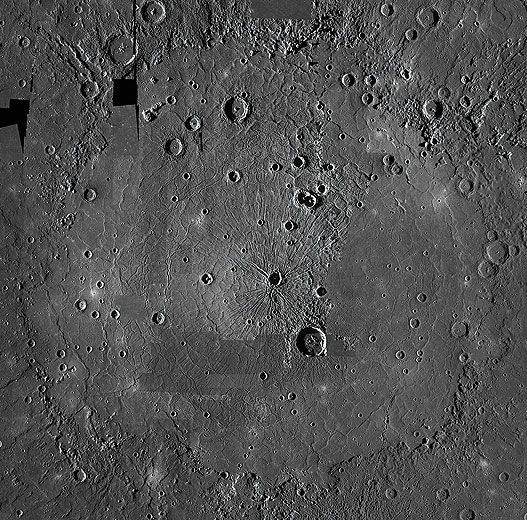
As thrilled as I was to see the data returned from the Martian arctic, I was just as mesmerized by the images returned from Mercury. MESSENGER (MErcury Surface, Space ENvironment, GEochemistry, and Ranging), which reached Mercury for its first flyby in January 2008, was the first spacecraft to visit the planet in more than 30 years. In the early 1970s, Mariner 10 imaged about 45 percent of Mercury’s surface and found a surprising magnetic field, a metallic core making up about 80 percent of the planet’s mass, an extremely thin atmosphere, and temperatures ranging from about 800 degrees Fahrenheit on the day side to about –300 degrees on the night side. Still, roughly half the surface of Mercury remained a secret. If beings from another world could see only 45 percent of our planet, imagine their difficulty in understanding Earth.
In my memory, the first MESSENGER flyby stands out the most vividly: It provided our first closeup view of the previously unseen hemisphere. As I joined a crowd around a computer screen and strained to see over shoulders and around heads, I made out the outline of the beautiful Caloris basin. Stretching almost 1,000 miles wide, it is one of the largest impact basins in the solar system. It was partially imaged by Mariner 10, but its full extent and details remained unknown until the day it drifted across our computer screens. I spent the next days and weeks poring over images that revealed a complex surface of impact craters, lobate scarps, wrinkle ridges, and other landforms—many of them observed on other bodies in the solar system, but now, on Mercury, telling a new and unique story. Last March, MESSENGER became the first spacecraft to orbit Mercury. It is still returning pictures—and clues.
Maria E. Banks is a planetary geologist at the center for earth and planetary studies at the Smithsonian’s National Air and Space Museum.