What Lies Beneath
You don’t have to go to the moon to find out what it’s made of.
/https://tf-cmsv2-smithsonianmag-media.s3.amazonaws.com/filer/What%20Lies%20Beneath%20FL.jpg)
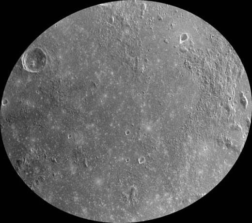
Six brief visits by the astronauts weren’t enough. With the surface area of Africa and Australia combined, says geophysicist Bruce Campbell, Earth’s moon still has a lot more to tell us.
More than three billion years of the solar system’s history lies there, from an ancient era of heavy asteroid bombardment to the thump of pebble- and grain-size meteorites today. Earth’s impact record is largely erased by erosion and plate tectonics, or buried by vegetation and oceans. But the moon’s is merely obscured by a layer of fine dust. Campbell is unveiling that hidden record.
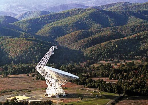
For peering beneath lunar soil, optical telescopes are useless, because wavelengths of visible light bounce off the surface. So Campbell, who works at the National Air and Space Museum’s Center for Earth and Planetary Studies, uses Puerto Rico’s Arecibo radio telescope—the world’s largest—as a radar gun.
“Arecibo’s two-million-watt transmitter can hit the moons of Saturn and pick up the echo,” Campbell says. That 1.6-billion-mile round trip requires a few hours. By contrast, Earth’s moon is just 240,000 miles away. “You can’t shift the receivers at Arecibo in the two and a half seconds before the echo returns to Earth,” says Campbell. So he uses the Green Bank radio telescope in West Virginia as his receiver, to avoid the physical problem of not being able to use both the transmitters and receivers at Arecibo. “That gives us lots of flexibility,” says Campbell, “and puts more power on the moon from Arecibo.” With advances in computing, Campbell has been able to fine-tune the resolution down to about 65 feet per pixel.
Campbell is making lunar maps from these images for two reasons. The first is to understand the moon’s fundamental geology, which illuminates how the solar system evolved. The second is to gather data about the lunar surface and subsurface for future explorers, robotic and human. Though recent efforts to return astronauts to the moon have been put on hold, NASA may one day use the maps, along with data from ultraviolet to infrared reflected light, to set up an outpost near deposits that could supply raw materials like iron or titanium, and feedstocks for oxygen and perhaps water.
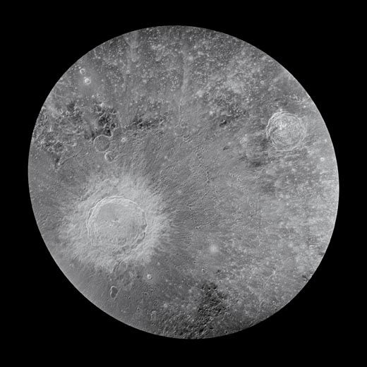
The color-coded mosaic shown above is oriented as if the viewer were hovering directly above the lunar South Pole, which lies at the bottom center. In some areas of the surface, the 70-centimeter wavelength penetrates up to 100 feet, “so we are ‘seeing’ geologic features that occur over that depth range,” says Campbell. Greenish hues in the hilly region to the left of the South Pole indicate rocks thrown from the large, multi-ringed crater at far left called the Orientale Basin. Pink and purple hues at the top are transitions to the large, flat mare, or seas, of basalts formed by volcanic activity several billion years ago. Oranges and reds represent a high proportion of fragmented and jumbled rocks in the upper 30 feet of the soil, particularly that in the bottom of the 63-mile-wide Tycho Crater, at upper left center, one of the moon’s most recognizable impact craters. “These crater floors retain very crackly lava-like deposits,” says Campbell, which do not show up in optical images. Tycho, named for the 16th century Danish astronomer Tycho Brahe, dates to 108 million years ago. Its high albedo, or contrast, with the surrounding moonscape, and the sharp definition in its crater rim indicate that it is one of the moon’s youngest large craters. In optical photos its reflective rays of ejecta extend for hundreds of miles in all directions, but radar peers through them. Tycho is hardly the most recent of all the moon’s craters. Says Campbell, “There were small craters formed on the moon yesterday.” But Tycho, several times deeper than Arizona’s Grand Canyon, is a portal through the lunar crust to a time just after the solar system’s most massive impact crater, the South Pole-Aitken Basin, was formed on the lunar far side (the South Pole lies on the huge crater’s rim). South Pole-Aitken preceded all other detectable impacts on the moon and hurled so much debris, some of it city-block-size chunks, that it coated large areas of the surface. Relatively young craters like Tycho bore down to that ancient bedrock. Over the last few years, with help from post-doctoral fellow Lynn Carter at the Museum, Don Campbell (no relation) at Cornell University, John Chandler at the Smithsonian Astrophysical Observatory in Cambridge, Massachusetts, and staff at the two telescopes, Campbell has produced a whole new mosaic of the moon’s Earth-facing side. (The far side cannot be mapped from Earth.)
Next up for Campbell’s radar mapping? Mars. “The rover pictures [taken on the surface by Opportunity and Spirit] show geology hidden by dust and sand,” he says. “So the technology that lets us look through soil on the moon will do the same for Mars. We want to use the moon science as the jumping off point for that.” But the distance from Arecibo to Mars means low resolution. So he has proposed a probe with radar instruments to orbit Mars and map the surface and subsurface at 60-centimeter wavelength and with better resolution than his moon images have. The side-looking imaging radar he has suggested would reveal geologic features 15 to 25 feet beneath the surface, with a resolution measured in tens of feet per pixel, as opposed to Earth-based radar images with a mile-or-two resolution.
For more radar images of the moon, see the gallery at right.
Michael Klesius is an Air & Space/Smithsonian associate editor.
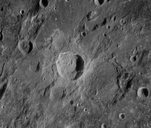
About 800 million years ago, an asteroid moving three to six miles a second created Copernicus Crater, the bright, 66-mile-diameter crater just left of center, named for the 15th century Polish astronomer credited with the heliocentric theory of the solar system. When Campbell pulses Copernicus with the Arecibo telescope, chains of smaller craters appear in sharp relief, spread in a diffuse ring far outside the main crater. “Each of those is bigger than [Arizona’s] Meteor Crater,” says Campbell. “They’re secondaries made by huge blocks thrown a hundred miles and more from the impact. They don’t have as much shattered material at their rims because the debris fell at a lower velocity than the initial impacting object.” He also points out the bright halo around Copernicus, which reveals a different ejecta pattern in radar than in optical. “The radar image shows us the rock abundance in the ejecta blanket,” he says. A landing inside Copernicus was on the schedule for Apollo 18, 19, or 20, but NASA cancelled all three missions. So the site is emblematic of unfinished business on the moon. Smithsonian/Cornell/Arecibo-NAIC/GBT-NRAO

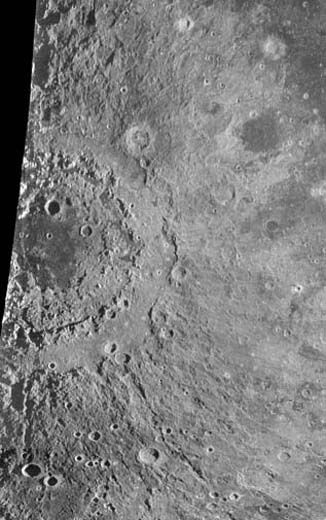
Radar pulls the veil from the 125-mile-square Aristarchus Plateau, named for the third-century B.C. Greek astronomer. The plateau is an island of lunar crust, uplifted by the impact of an asteroid about 3.85 billion years ago. “We’re fuzzy on the ages,” says Campbell, “because we have firm dates only from the Apollo samples.” Those samples, dated with a method that spans billions of years, provide the dates that have yielded our present-day understanding of the inner solar system’s geologic history. More than three billion years ago, the plateau’s volcanic deposits spewed from the “cobra head,” Campbell says, at the top of the rille called the Vallis Schröteri, which cuts a right angle in the plateau. Fallout cooled into micron-size beads that piled up as glass or fine-grained ash up to 100 feet deep, like icing on a cake. The bright crater at lower right, also named Aristarchus, measures 25 miles across and was born of an impact within the last billion years. The mile-high plateau is frequently suggested as a locale for a permanent outpost where humans could mine its iron and other deposits. While Campbell’s images don’t show the actual chemical content of the soil, his radar signals scatter in ways that are affected by its iron and titanium content. “So the main thing the radar shows you is how clean the deposits are,” says Campbell. “Ejecta streaks on the plateau in the radar image result from baseball-size rocks thrown out by the impact event that created the Aristarchus Crater, which are not as visible in the optical images because they are often buried in the volcanic material. The streaks tell you about the resource potential. You want to pick a radar-dark spot where you’ll have clean, fine-grained material to excavate. So it’s a good safety check on an optical image.” Smithsonian/Cornell/Arecibo-NAIC/GBT-NRAO